Pathways of Pioneers
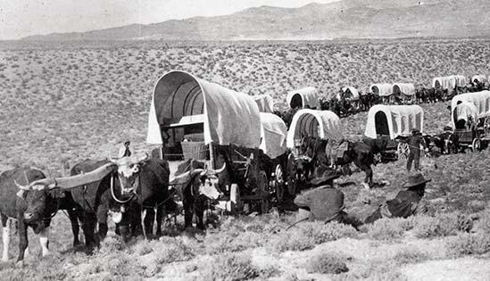
The great migration west along the Oregon and California Trails shaped the course of a nation and forever altered a way of life for Native Americans. For the emigrants, the Oregon country offered them a chance for free land and a better life. That chance would come at a cost, though, as nearly one in ten died along the way. Sacrifice and determination walked hand in hand with the pioneers striving to reach their westward goal.
The change set in motion by the great migration left a lasting legacy on Idaho and the rest of the country. Traces of the journey are now hidden amidst the intractable march of progress. Learn more about the trail and its twisting course through our state and the west as Outdoor Idaho follows the Pathways of Pioneers.
Introduction to "Pathways of Pioneers"
Landmarks
Not long after the emigrants crossed Thomas Fork Creek in what is now Idaho they faced one of the most challenging obstacles of their journey…Big Hill. A strenuous uphill climb was followed by one of the steepest descents along the entire Oregon Trail.
"We went a few miles further when we had to cross a very high hill, which is said to be the greatest impediment on the whole route from the United States to Fort Hall. The ascent is very long and tedious but the descent is still more abrupt and difficult." --Theodore Talbot, Sept. 7, 1843
"And the braking systems they had on those wagons weren’t the best. They were hand held and hand held metal on metal almost but you can’t let your wagon run into the back legs of your livestock. I just think they had to work with the hand that was dealt them. There you are in July, it’s hot, you’ve got this hill, and it’s going to be tough. We’re going to work together and we’re going to take a wagon at a time. It’s going to take us all day to move all the wagons over but that’s our day." --Ross Peterson, Historian
"Oh my, just the steepness of it alone. Here they are trying to hold back wagons down a grade that in a diary entry said was as steep as a slope of a calf’s face and sheer granite with not a lot of dirt… so they were trying to hold back an immense amount of weight there and then to know that every possession you ever owned, the only thing you owned in your whole world was on the back of that wagon coming down. It was a tremendous feat that they came down." --Becky Smith, National Oregon-California Trail Center at Montpelier, Idaho
The Clover Creek camp site on the Oregon Trail was located in the Bear Lake Valley where Montpelier, Idaho stands today. It was a welcome stopping place for the emigrants who had crossed the desert of western Wyoming and overcome the challenges of Big Hill.
"There were all these fresh, refreshing rejuvenating things waiting for them in this valley to be able to spur them on, because once you leave the Bear lake Valley you go back into that wilderness or that desert especially down by the Snake River and the Massacre Rocks area." --Becky Smith, National Oregon/California Trail Center at Montpelier
As director of the Oregon/California Trail Center, Becky Smith appreciates the facilities historic location on the Clover Creek encampment site. The center celebrates the heritage of the trail and also gives visitors a feel for the journey with their living history presentations. Through her various roles at the center Smith feels she’s continuing the legacy of the Oregon Trail.
"Well I do feel a connection with the pioneers who have travelled this way and especially when I work here at the Oregon Trail Center. It’s so important for us never to lose that zest for life that they had, that there is a chance that you can do something over or you can make it better and I think if I had one wish it would be to be able to every so often recreate that and have more facilities like this where people can come and touch base with the past, learn from the past so that we’d have a better future." --Becky Smith, National Oregon/California Trail Center at Montpelier
Continuing up the Bear Lake Valley from Clover Creek (Montpelier), Oregon Trail travelers soon reached the next important stopping place, Soda Springs. The area was well known by emigrants for its abundance of unusual springs.
"Travelled about 22 miles along the bank of the Bear River and are encamped at Soda Springs. This is indeed a curiosity. The water tastes like soda water, especially artificially prepared. The water is bubbling and foaming like boiling water." --Sarah White Smith, July 24, 1838
"You could hear Steamboat Springs which was the most renowned one as you came into the valley from the east they could hear rumbling and roaring. And there were just a huge number of carbonated springs, regular springs, cold water and just sulfur type smelling springs. The whole area was laced with them. And they camped and explored, probably spent a few days here. It was quite a phenomenon to them. And on a calm day you can go out on the back of the golf course, you can look over the reservoir and you’ll still see the rings as Steamboat continues to bubble." --Tony Varilone, local historian
Alexander Reservoir now covers both Steamboat Springs and sections of the Oregon Trail that pass through the area. But if they look closely, visitors can still see wagon ruts running through the nearby golf course and at Oregon Trail Park on the shores of the reservoir.
In the towns Fairview cemetery the wagon box grave provides another direct tie to the past. It contains the remains of a family of seven who were killed by Indians after staying behind the main party to look for lost horses.
"It’s called the wagon box grave because they dug a hole, put the wagon box – took the wheels off – put the wagon box in the bottom, covered them up with their blankets and buried them and marked the grave. And there were enough people still hanging around or who were hanging around in this area that it became known as the wagon box grave and permanently marked." --Tony Varilone, local historian
Fort Hall was one of the most important landmarks on the Oregon Trail. The British trading post was originally built by American Nathaniel Wyeth along the Snake River in 1834. Three years later, in 1837 it was purchased by a Britain’s Hudson Bay Company. They improved the structure by encasing the square log stockade with adobe brick.
"Paid a visit to Capt. Grant. Fort Hall is a small and rather ill constructed Fort, built of 'Dobies.' It was established in the summer of 1834 by Nathaniel Wyeth, a yankee. He could not compete with the H.B. [Hudson's Bay] Company and finally sold out to them. The Fort is near the entrance of Portneuf into Snake River. The river bottoms are wide and have some fertile lands, but much is injured by the slat deposits of the waters from the neighboring hills. Wheat, turnips have been grown here with success. Cattle thrive well." --Theodore Talbot, Sept. 14, 1843
Within a few years after the British purchased the post it became a major stopping place for thousands of Americans travelling west along the Oregon Trail.
"It was really the only place where they can have supplies, where they can meet other people and where they can take a break between Soda Springs and the rest of the most arduous part of the journey. It plays a significant role in the landmarks of the trail and so for trail travelers they are keeping track of where they are according to landmarks like South Pass and Fort Hall. The Hudson Bay Company though is a British trading firm. They really don’t care about American settlement and ultimately they will be forced to leave the region so, it is an ironic relationship there." --Laura Woodworth Nye, History Chair, Idaho State University
Fort Hall was shut down in 1855 after the Ward massacre which occurred in the Boise area much further west on the trail. But the escalated tensions between the emigrants and the Native Americans made commerce difficult. The U.S. military built a second Fort Hall years later northeast of Snake River. The original Fort Hall quickly fell into disrepair and little remains of it today. The site, marked with a simple marker is all that remains today. It is on the Shoshone-Bannock reservation and tribal permission is needed to visit the area. If you want to see what Fort Hall used to look like an excellent replica has been constructed south of the reservation in the city of Pocatello.
By the time the wagon trains reached what is now Massacre Rocks State Park, the emigrants had travelled over twelve-hundred miles from Missouri. Many considered their trek through the Idaho desert as one of the most difficult parts of the journey. Today, cars and trucks speed down today’s Interstate highway with few realizing how the pioneers struggled to cover the same ground.
"The Oregon Trail here essentially is in the middle of the interstate. The emigrants for the most part followed right where highway 30 was and then when the interstate went through the interstate just simply took out more of the Devil’s Gate. The Devil’s Gate or the Gate of Death is still there. It’s just slightly larger than it was during the Oregon Trail era. When the Oregon Trail was going that gap through the rock was only wide enough for one wagon to go through. Even though no attacks of emigrants happened there to the emigrant’s point of view Massacre Rocks—attack sketch [Courtesy Idaho State Historical Society, 60-150, Shaw]whenever they had to go through a very narrow gap of rocks or through trees or a canyon they were always concerned about being attacked. The actual Indian skirmishes that happened in 1862 happened further east of what people termed the Massacre Rocks even though that name never came about until much later." --Kevin Lynott, Ranger, Massacre Rocks State Park
The attacks that took place on August 9th and 10th of 1862 occurred along the trail east of the rocks. They claimed the lives of ten emigrants and involved a total of four different wagon trains.
"Mr. Hunter, who was captain of our little train gave orders to get ready their firearms and prepare for fight, and right speedily was the order obeyed, considering the surprise in which we were taken, together with the fact that not one of us had ever been called upon to defend our lives or property by the use of such weapons." --Charles Harrison, Aug. 11, 1862
Visitors who stop at the state park today can learn more about the attacks and also get a close up look at some well preserved ruts or swales.
"Here the more common term is swales. Ruts are what you consider of twin wagon wheels shown in rock. Here, because it’s highly erosive ground what you have is more of a ditch effect. Unless they had no option whatsoever to bypass rocks you very seldom see ruts per se. You see swales across Idaho for the most part." --Kevin Lynott, Ranger, Massacre Rocks State Park
A few miles west of the swales, the names carefully etched into Register Rock reach back to the days when this area was a prime camping spot on the Oregon Trail.
"Register Rock was one of the more popular camp sites in the area and that was principally because Rock Creek was emptying into the Snake River there so there was better feed and it just happens that the Bonneville Flood had rolled a huge boulder right in the middle of their camp ground and so early on the emigrants , where ever they could, left their mark. Sometimes it was just a pencil drawing on an oxen skull but where there was rock and where they had time they actually chiseled their names into the rocks and there are several hundred here. Some have been lost just through erosion through the years but you can still see quite a few names." --Kevin Lynott, Ranger, Massacre Rocks State Park
From the Massacre Rocks area the Oregon Trail continues west, generally following today’s interstate highway. When the emigrants reach the Raft River valley in the 19th century there was a broad river to cross. All that’s left of the river today is an irrigation ditch.
show text
But on the plateau above the river valley is a major landmark of the trail…the Parting of the Ways. Here emigrants heading for the gold fields would turn towards California while those bound for Oregon would push on due west.
"At noon crossed Ford Creek & at night reached Raft River & encamped. Grass good. At this point the two trails diverge for California and Oregon. We met here quite a train taking the Oregon Trail, mostly families." --Henry Tappan, July 23, 1849
"Until 1849 the Oregon Trail is headed predominantly to the Willamette Valley and once the Gold Rush takes place in 1848, 1849 then the majority of travelers on the Oregon Trail will be headed to California and so it’s really a misnomer to say that it is the Oregon Trail because it becomes the California Trail once those travelers turn off, and they diverge just south of what is now Raft River Idaho and they head into Nevada and into the Sierras ultimately." --Laura Woodworth Nye, History Chair, Idaho State University
Just below the Parting of the Ways is the lonely grave of a woman who died from wounds suffered during the Indian attacks in the Massacre Rocks area.
"Mrs. Adams, who was wounded in the fight of the other train, died last night. We buried her this morning. Here some of our train will leave us and take the road to California." --Robert Scott, August 12, 1862
Emigrants heading southwest on the California Trail followed the Raft River for many miles. Later they would reach another landmark not far from the current Idaho/Nevada border . . . the City of Rocks. Today, the area is protected as the City of Rocks National Reserve.
The emigrants were impressed with the huge stones and boulders they found here. Some stopped long enough to record their passing by writing their names on the rocks with axle grease.
"This morning we started early, at half past five o'clock and nearly all day traveled over rough roads. During the forenoon we passed through a stone village composed of huge, isolated rocks of various and singular shapes, some resembling cottages, others stooples and domes. It is called 'City of Rocks' more suitable. It is a sublime, strange, and wonderful scene—one of nature's most interesting works." --Margaret A. Frink, July 17, 1850
Rock Creek was a prime camping spot and resting place along the Oregon Trail. In the mid 1860s a stage station and store were built near the creek.
"One of the journal entries called it an oasis in the desert. It was an important stopping place. They could stop here, they could get water, they could bathe, they could fish. It was important because of the creek." --Curtis Johnson, Friends of Stricker
Today, there’s not much left of the stage station although the 1865 store is still standing.
"You wouldn’t know by looking around now but it was the largest stage station between Fort Hall and Fort Boise so it was a very important stopping place. The stage station itself was a lava rock station with a sod roof and it could house up to forty horses and it also meant you could get a warm meal here in the evening time. And the store was built to provide supplies and it was located here because of the lava rock cellars behind it." --Curtis Johnson, Friends of Stricker
In 1876, Herman and Lucy Stricker bought the store and later built a home on the location. Curtis Johnson is their great grandson.
"To me this represents how history shifts and moves so easily. When Herman and Lucy were living here this was a major thorough way. This was like the freeway of the 1800’s and then the railroad came through on the other side of the canyon and it kind of shifted the whole migration of people to the other side of the canyon. To know where we came from helps us value where we are today." --Curtis Johnson, Friends of Stricker
The Stricker Store and Home are owned and managed by the Idaho State Historical Society with help from the Friends of Stricker. There is a new interpretive building at the site that provides additional information on the history of the area.
At Three Island Crossing emigrants on the Oregon Trail reached a critical junction. Here they had to decide whether to make the difficult crossing of the Snake River or take a longer alternative route along the south side of the river.
"Some of the hardest things the emigrants had to do were crossing rivers. When you read the diaries there are a lot if incidents of deaths at the river crossings. So when they get to Three Island Crossing they’ve got a decision to make. They could continue on down the south side of the Snake which was known as the dry and the longest route and the more desolate Wagons crossing riverroute or they could risk crossing. …. So it was whether you wanted to risk drowning or take the long route." --Larry Jones, Idaho State Historical Society, retired
Today, local residents in the Glenns Ferry area honor their pioneer heritage during the annual Three Island Crossing event. Every August, since 1985 they’ve reenacted the crossing at this historic spot.
The area is now an Idaho state park complete with a history and education center. Yet, actually witnessing a crossing leaves a vivid impression on the hundreds of spectators who line the river. Roy Allen has been part of the event for over twenty years and has participated in all but two of the reenactments. In his late seventies he’s the oldest man still crossing the river.
"It’s a little bit exhilarating when you know you’re coming into the swimming water, pretty quick you feel your old horse start swimming instead of walking, you hope he can swim good." --Roy Allen, long time Three Island Crossing participant
For many onlookers seeing this crossing is more real than any history book could ever be. And for the participants there’s great meaning in continuing this tradition.
"Both sets of Great Grandparents crossed this river, so it’s a way to honor them and remember them and when we make it across its such jubilation you know when you think about your heritage and how your ancestors must’ve felt and you thank God that you’ve made it and everybody’s safe." --Julie Blackwell—Three Island Crossing Participant
The point is named for U.S. Army Captain Benjamin Bonneville, an early Idaho explorer whose party reached this viewpoint along an old Indian trail in 1833. Later, it became a fondly remembered location for emigrants on the Oregon Trail as they took in their first view of the Boise River Valley.
"The real viewpoint for them is when they get on Bonneville Point. They hadn’t seen trees for many miles and when they are on Bonneville Point and they are looking over the beautiful Boise valley they see the greenness along the river, the trees and the grass they know they’re going to have good water and they are going to have good grass once they get down there. So that was a pretty joyous occasion for all of them when they get up there." --Larry Jones, Idaho State Historical Society, retired
"It was getting late when I reached the top of the Big Hill, around which the road leads to the Plain, which is spread out at its base, almost as far as the eye can reach; broken in the distance by the Mountains in the regions of the Malheur & Burnt Rivers. To the right rose up that majestic Range of mountains, which is the source of the river below, and from which we issued yesterday. Below, thousands of feet below, were seen the water of this beautiful river winding there tranquil course & gleaming like a thread of silver in the rays of the setting sun. The stream seemed as calm and gentle, as if its way was through a meadow, instead of rugged canyons. After reaching the plain, the course of the stream is marked by a line of green timber, which gave rise to Bonneville point—view from pointits name among the early trappers 'Boisse' or the 'Wooded River'. This green strip of vegetation winding its way through the desert sage plain, gave a more cheerful prospect to the view and after gazing once more on the vast map spread out before me I rapidly descended the hill to find a camp for the tired train; but never can the recollection of the grandeur of that scene be blotted from memory... . the sunset from the Big Hill of Boisse will always be a greene spot in the past." --Winfield Ebey, August, 1864
Today, Bonneville Point is a Bureau of Land Management site complete with interpretive signs and historical markers. And though it has changed significantly in the last century and a half, there’s still a great view from the point.
The city of Boise actually owes its beginnings to the United States Military’s Fort Boise. While the original Hudson Bay’s Fort Boise was a trading post built years earlier on the Snake River, the military fort was constructed near the Boise River in 1863.
"There was talk that we needed military help for the emigrants coming through. Nothing happened until after gold is discovered up in the Boise basin and then the movement really took hold and we have Fort Boise the military one founded on July 4th, 1863 to serve not only the miners and the new settlements starting to grow up but also the emigrants who were still coming through.
We still have some of the original buildings there from 1864 and 1865 and up to the turn of the century so it is a place where you can go over and see what a military encampment might have looked like – and Fort Boise was economically one of the boons for Boise city for many years. --Larry Jones, Idaho State Historical Society, retired
Fort Boise was originally constructed near the intersection of the Oregon Trail and the roads connecting the Silver City and Idaho City mining areas. Today, all around Boise you can find plaques marking the route of the Oregon Trail through the city.
Fort Boise was originally built by Thomas McKay of the British Hudson’s Bay Company in the fall of 1834 near the confluence of the Boise and Snake River. The post was a response to Fort Hall, the trading post built by American Nathaniel Wyeth a couple hundred miles upriver on the Snake near what is now Pocatello, Idaho. The Hudson’s Bay Company would soon own both forts but with the decline of the fur trade the posts served became primarily used as rest and resupply stops along the Oregon Trail for the thousands of American emigrants who were heading west.
"We reached Fort Boise. This is a trading post of the Hudson's Bay Company, established upon the northern side of Snake or Lewis River, and about one mile below the mouth of the Boise River. This fort was erected for the purpose of recruiting, or as an intermediate post, more than as a trading point. It is built of the same materials, and modeled after Fort Hall, but is of a smaller compass. Portions of the bottoms around it afford grazing; but in a general view, the surrounding country is barren... At this fort they have a quantity of flour in store, brought from Oregon City, for which they demanded twenty dollars per cut, in cash... At this place the road crosses the river, the ford is about four hundred yards below the fort, and strikes across to the head of an island, then bears to the left to the southern bank; the water is quite deep, but not rapid..." --Joel Palmer, September 2, 1845
Fort Boise was particularly susceptible to flooding and was actually moved several times in the generally vicinity of the confluence. Both Fort Boise and Fort Hall were shut down after the Ward massacre in 1854 escalated tensions between the emigrants and the Native Americans. Boise River floods destroyed all remnants of the fort by the 1860s and today all that left is a small historical marker.
The site is listed on the National Register of Historic Places and is found inside the Fort Boise Wildlife Management Area. Though the fort is no longer there visitors can get good views of the Snake River from the river banks where the post used to stand.
In Parma, just up the road from the original fort site, there is a replica of Fort Boise and additional historical information.
Trail Historians
Idaho State Historical Society, retired
John Crancer – What is the Oregon Trail?
Larry – For everything to come together as with every movement there needs to be an atmosphere right for change and this was certainly the case in the late 1830’s and the early 1840’s. Malaria was running rampant in the Mississippi Valley, there was a depression and there had been lots of information available in the last few years for them about the Oregon Country.
The primary information coming out was this should be our land – not England’s. In 1818 we signed a joint occupation with England and Great Britain for occupation of the land. So the theory was if we got all the white settlers over there then we’d have a stronger case to make for the land. So with that intact and the settlers around there having some problems some of them decided to immigrate.
The big emigration starts in 1843 and there were nearly a thousand of them and prior to 1843 there had been a few who went to Oregon following the missionaries and looking for farm land but they had never been able to take their wagons past Fort Hall. They were always told that it was too rough. Marcus Whitman had gone back to the east to try and get more money and support for his mission and he met them near Fort Hall and he said we can take wagons. So they were the first ones to take wagons through and then once it was proven that wagons could go through then more people started to come. They didn’t come in droves at first. Prior to 1848 there were probably 15,000 who came and probably 4,000 or less who went to California but then what happened in 1848 was the discovery of gold and that gold fever pretty much swept the nation and then we start seeing more and more coming along the trails. Not all of them are going to California. Some of them still go to Oregon but the vast majority of them were going to California but they were still using trails that we have here in Idaho.
John – What were the prime years of the trail and how many travelers were there?
Larry – The prime years of the trail itself were probably 1841 to 1860 according to most historians and during that time, that is when we have pretty much a rough estimate of how many were going.
They say – depending on who you look at for estimates that 400,000 to 500,000 went to the west coast. The majority of those went to California and during that time period there were probably 100,000 who went to Oregon. The rest were going to California. Now that estimate is going to go up some because the Oregon/California Trails Associations have been researching the southern trails which have never been looked at before so that will probably add to the total during those years. But I have found after 1860 we still have more and more coming, using the trails because of gold discoveries, the opportunity for free land and cheap land and so we could probably add a few more thousand on to that.
The last good immigrant diary we’ve got is 1919 and we know there were people still taking wagons at that time. Even when the train came through and came to Kelton people were bringing their goods and buying wagons or shipping the wagons out after 1869 and coming, migrating into Oregon and Idaho at that time.
John – We’re talking about that there were still people on the trail until the early 20th century.
Larry – Right, until the development of the automobile and then even then in some remote areas we still have people still using their wagons. So the trails were in use probably into the ‘20’s and even probably the ‘30’s until there are more and more automobiles and then even then people tried to drive their autos, in the beginning on the trail and that didn’t work too good so they had to find new routes for the roads.
John – What kind of people attempted this journey? Who was travelling?
Larry – There is a whole spectrum of people who were travelling. In the beginning you mostly get farmers and some businessmen and entrepreneurs. You get what you might call today the wanderers or you might have called them hobos or whatever, they were drifters. And they really had no place to put their hat down in the Midwest and they were hooking on and trying to get a new start for themselves coming out. So you have a whole myriad of different types of people who were coming out here – but mostly its families looking for new opportunities
Now, it is always thought that these people were poor people when they were coming out here but that is another misconception because when you look at what it costs to come out here at that time with the wagon and outfit you are looking at four or five hundred dollars anyway and that was a lot of money back in the 1840’s. So these were fairly well to do people who were just moving on. And then you might get the occasional person who might move on because his nearest neighbor was within ten miles and he thought that was too close so he was going to move on farther west.
John – What were some of the biggest challenges along the trail?
Larry – Every day was really a challenge for them. They never knew what they were going to run into – in the beginning. Later on they had a good idea of what the challenges were before them but the real challenge for them was the camp grounds. They always had to have wood, water and feed for their animals. In the beginning, there was not too much problem finding these campgrounds but when you start – especially until they get over into Idaho – when you have like in 1852, you have 50-60,000 people going over the same trail, that is going to decimate the environment pretty good and that was also the time when they have all the cholera epidemics along the trail, when thousands die because of all the polluted water and all the waste along the way.
John – What were the essentials to make this trip?
Larry – Again, they always wanted to take grandfather’s clock along and there are a lot of grandfather’s clocks that ended out on the prairie. Some historians have called the trail just one large garbage bed.
The recommendation was that your wagon shouldn’t be overloaded. They thought the ideal weight was somewhere around 1,200 pounds. Some people would start off their wagons with over 2,000 pounds and that would include beds and stoves and all sorts of iron implements and those soon met the wayside. But you always wanted to have a good supply of food. They would have bacon and beans and rice and tea and coffee and sugar and flour. Those were some of your essentials that would get them out here.
In the beginning people thought that they could shoot wild animals along the way but that didn’t last for more than one or two years before the animals figured out they didn’t want to be anywhere near the trail and there just wasn’t much there for them. So they had to depend on some of the trading places that grew up along the trail from retired mountain men and so forth who would start trading spots along the way. Fort Laramie, Fort Bridger, Fort Hall and Fort Boise would be places – where if they had money – again, these people had to have some money with them to buy supplies and then they had ferries along the way that if they had the money they would get ferried over rather than try the dangerous crossings themselves. So it was a pretty expensive operation really, when you stop to think about it in terms of today’s money.
John – Why were there so many variations on the trail?
Larry – Again, it goes back to what we talked about – the essentials they needed for camping spots – the wood, water and the grass and as they would become decimated they looked for better ways. And once the gold fever strikes then you are looking for the fastest and the shortest way and so then you have new cut-offs that start up that they think are going to be faster when in reality most of them don’t turn out to be any faster. They are closer but they are harder and the time wise is pretty much about the same.
And then we get the government involved with the Lander Road which is our only government surveyed road for the emigrants in 1857 and again that was trying to make it a shorter and better travelled way for commerce to go back and forth. That didn’t really work either because it was shorter but again, on the Lander Road when you are going over a mountain range that is over 9,000 feet high you can imagine it takes you a while to get your team up and over that and down – although the grass and the water were better along that route and that route was later used along with Goodale’s Cut-Off for the cattle drives once we had a settlement out here and they are going back east to rail heads, they went these ways.
John – Did they do some improvements on the Lander Road?
Larry – Yeah. On a lot of the stretches they didn’t need to do it on but when they go directly west from south pass and over the mountain - Jim Bridger Forest and over in there - they had to do a lot of road construction and somewhat in Idaho too when we get over into the eastern Idaho section of it over by Kennikinet Canyon and over in there which is just west of the Fort Hall Reservation. It’s also called Terrace Canyon. You can still go over there today and see the rock work they did coming up through the canyon to get them up and over. And then when they get over into the Fort Hall area where they meet up with the main trail then there is not much road improvement until they get over into Nevada – today’s Nevada.
John – Give us a brief description of Goodale and why that was used.
Larry – Goodale was first discovered by the fur trappers and was later used as a route for some of them who were supplying the Hudson Bay post at Fort Hall. We know it’s also another shorter route and once you get through the Craters of the Moon it is pretty well watered and there’s lots of grass. We’ve got travelers going that way in 1852 and 1854 but it is a tough route until you get past Craters of the Moon so it didn’t really attract too many. But in 1862 when we were having all the problems with the native Americans west of Fort Hall a train of about a thousand met up with a retired or semi-retired mountain man, Tim Goodale and he took them on the Goodale Cut-Off and then it became a little more popular once we have all these people going that way. And it was also a route used – after settlement again, where they would take horse and cattle herds east of the trail heads in Wyoming.
John – What about the Hudspeth cut-off? What was the main motivation for that?
Larry – It’s the shortest route. But again, they forgot that they had to go over four mountain ranges. This was opened up in 1849. It takes off, instead of going northwest from over in the Soda Springs area, it went straight and they thought they were going to come out on the Humboldt. When they discovered that they didn’t come out on the Humboldt but they were still just about 80 miles south of Fort Hall one of them said that he was thunderstruck that they weren’t on the Humboldt already.
They also were somewhat dismayed to find out that the people they separated from who went up on the traditional California trail at that time through Fort Hall and then down Raft River, they met up at about the same time in City of Rocks. But it was shorter. If you were packing or on horseback or mule it probably would have saved you a little more time. But if you had wagons it wouldn’t have saved you hardly anything, but to them it was shorter.
John – Talk about Three Island Crossing and why that was such an important junction.
Larry – Some of the hardest things the emigrants had to do were crossing rivers. When you read the diaries there are a lot if incidents of deaths at the river crossings. So when they get to Three Island Crossing they’ve got a decision to make. They could continue on down the south side of the Snake which was known as the dry and the longest route and the more desolate route or they could risk crossing. Those who crossed would find better feed and wood and water but they would also have to cross the Boise again and then they would have to cross the Snake River again. And both of the routes came together just west of Fort Boise. After they crossed the Snake River at Fort Boise they would rejoin together. So it was whether you wanted to risk drowning or take the long route. And it would all depend on the time of the year they were there and what the water looked like – because we know today even from the crossings they have there, there are holes out there and that is what a lot of them found when they were going across.
The early travelers would meet in an Indian encampment there and the Indians were most helpful for a small pittance to help the emigrants get across and everything was fine. When we have problems with the Indians later on you had to pretty much make that choice on your own and some of them even thought that well, this is such a thing, once we got our wagons all caulked up let’s just float on down to the mouth of the Columbia or down to Portland. Well, as you might imagine that didn’t work either. Some of them tried that and one of them – the people who went by oxen train met the people, they were there before the people came down the river in their wagon. And some of them who started on their wagons we don’t know what happened to them.
John – How did they use the islands on the crossings?
Larry – They usually just used two of the three islands. If the water was right, the one island, the big island, the farthest one I guess to the southwest they would drive their cattle or horses on out there to feed but they would head upstream to get the right channel to get across. So they would usually mostly only use two of the islands.
John – How did the Snake River crossing compare to Three Island versus the one near Boise?
Larry – The one at Fort Boise would probably be just a little bit harder because they didn’t have the islands as sort of a stepping stone to get across and the one at Fort Boise usually could run a little swifter and could be a little deeper. They had some islands out there but they didn’t use those so it could be a little more dangerous. But again some of our retired fur trappers and the Indians at Fort Boise got together canoes and makeshift rafts and again, would charge them to go over. But it was a little more difficult crossing than Three Island.
John – What percentage folks went on the main trail versus the south alternate?
Larry – From my research and looking at the diaries I always thought it would be more that crossed because of the better camping sites but it is probably pretty much close to 50-50. It’s pretty close.
John – Describe the south alternate route. Give us a little more detail.
Larry – They encountered more of the desert aspects of what they’d come through. There would be a lot more alkyl idée dust and prickly pears and sage brush and there was some water but the grass – it’s a little dryer there and when they go on the north side they are right along the foothills so they are going to get the last good water and the last good grass where out there on the plains, more or less along the desert floor, they are going to be more in a desert environment and the chances for good grass and water are not quite as good as they are on the other side. But they would have some good geographic features to see. They would see Wild Horse Butte and they would be really close to the Owyhees. They would have some good views.
John – What would they see along the main route there?
Larry – They would get a few more creeks to pass which was good for the water and once they get over past Canyon Creek and up through that way they’d get into some granite again and again, that is where we’ll have some signature rocks where they can put their names upon the rocks and let people know that they were there or else let the relatives coming behind or whatever know they were on the right path and this was the way that they were going.
The real viewpoint for them is when they get on Bonneville Point. They hadn’t seen trees for many miles and when they are on Bonneville Point and they are looking over the beautiful Boise valley they see the greenness along the river, the trees and the grass and the smoke fires – the early ones of the native Americans and they know they’re going to have good water and they are going to have good grass and a chance to get fish to supplement their diet once they get down there. So that was a pretty joyous occasion for all of them when they get up there.
John – Just a little more on Canyon Creek and what kind of camp spot that was.
Larry – It was a good camping spot. They’d come through over by Teapot Dome Hot springs which is just north of Mountain Home. They had had a chance to rest and recuperate and wash their clothes and then they would hit another good creek at Rattlesnake Creek. But then at Canyon Creek they actually had a chance if they had time to maybe catch a fish or two to get through there and it is kind of a little green oasis. Of course when you’ve got a lot of people coming through the good grass along there is not going to last too long. But what happened as settlement goes and we have the development of stage lines we have a nice stage station put in there – Rock Stage Station which we can still remnants of today, and people always enjoyed there because they could always depend from the Daniels Family who built it and maintained it a nice trout dinner. So they all looked forward on the stages coming through there. Not so much in immigrant days because they didn’t have time to get a fish and pull out or dynamite to dynamite the fish or whatever they might have done.
John – More on Signature Rock and what you’ve seen there?
Larry – Over on Ditto Creek we do have a signature rock the people have left their names on right along the trail and again, you wonder why they leave their names on it and a lot of them when you read their diaries you will run across once in a while, or somebody says we left our names for one of the relatives or friends who are coming behind so they could have the idea that they were on the right track. And some of them they were taken by the history of it saying well, we’re here. Let‘s make this known that we were here and you can still see some of the names today.
John – Give us a brief overview of the different versions of Fort Boise.
Larry – It was recognized early on near the mouth of the Boise River that this was a place that the Native Americans like to come and have their festivals. From different states all around the Indians would gather there so when the overland historians came in 1811 they made note of this and they sent back John Reed to develop a small post there in 1813. Well, in 1814 the Indians didn’t care for him there and they soon wiped him out and so there was not much thought given to it until a few years later when Donald McKenzie who came out with the overland historians and then went back to Canada, he came back as a north westerner, with the Northwest Fur Company and he thought it would be a good place to meet and trade with the Indians but the Indians weren’t quite ready for him either at that time.
So nothing happened until 1834 when Nathaniel Wyeth came out and he had a lot of goods and he was going to supply the rendezvous over on Green River. Well, the rocky mountain people said they didn’t meet him anymore because Sublet came through with his supplies. So Wyeth headed on west and when he got over into the Fort Hall area he saw that this was a place where the Native Americans like to come so he built Fort Hall as a trading spot and then he went on west. Thomas McKee of the Hudson Bay Company was aware of this and he immediately talked the people at Hudson Bay Company into letting him start a Fort Boise as the Fort there that we know today even though it did move its location a couple of times as a supply point. And it lasted a little longer than the one at Fort Hall because going back just a little bit – when we had the 1818 joint occupation, by 1846 the U.S. had taken possession of the Oregon Territory. So in effect the Hudson Bay Company was on American soil and they lasted until about 1855 and they weathered some of the floods that came through but what they couldn’t weather was after the Ward Massacre and the problems with the Native Americans and then the Hudson Bay Company abandoned Fort Boise.
John – What were the prime years of the original Fort Boise?
Larry – 1834 to about 1855 were the prime years.
John – Talk about how it was used by the emigrants.
Larry – They looked forward to being at Fort Boise because Francois Payette treated all the emigrants quite well and he didn’t highjack them too much on the prices. And he also had a little small vegetable garden where the emigrants could get some vegetables if he had some left. So they all looked forward to going to Fort Boise.
And also when they got there some of his voyagers were also helping to run the ferry to get across there.
John – So it was a major landmark?
Larry – It was a major landmark and then even after we have the gold discovered and ferries developed there was a river site ferry put in there in 1863 that ran for a number of years until we have bridges put up. And that is also the place where the steamer Shoshone was built to supply the gold mines. Of course that didn’t work much because you need wood to run steam and when you are going up and down the snake river there is not much wood around. So the steamboat Shoshone didn’t last too long and it made a wild ride down Hells Canyon and eventually ended up over around Portland.
John – Talk about the second military Fort Boise.
Larry – The military Fort Boise, there was movement to get that fort build early even after the Ward Massacre. There was talk that we needed military help for the emigrants coming through. Nothing happened until after gold is discovered up in the Boise basin and then the movement really took hold and we have Fort Boise the military one founded on July 4th, 1863 to serve not only the miners and the new settlements starting to grow up but also the emigrants who were still coming through.
And the military played a big role in the development of southern Idaho because they would send out troops to help protect the trail and then we still had some Indian difficulties in the 1860’s and not until after 1879 did all this stop.
John – What can you see in the Boise area today with the original fort and some of the other areas?
Larry – Fort Boise, we still have some of the original buildings there from 1864 and 1865 and up to the turn of the century so it is a place where you can go over and see what a military encampment might have looked like – and Fort Boise was economically one of the boons for Boise city for many years until it was abandoned in 1913.
We can also see nearby here Bonneville Point where there is a small interpretive site up there that the BLM maintains and we also have the Oregon Trail historic preserve when sub-divisions were being built out there a number of agencies got together and thought we needed to preserve some of this and so it is a wonderful place where people can go out. There are three overlooks and a number of interpretations along there and that’s the actual remnants of the trail.
We also have just further west of here over near Middleton is the site of the Ward Massacre and there is some new interpretation there. It’s a nice little park where you can go and read about what happened there.
And then Canyon Hill where we are still working. Hopefully we are going to get something done to preserve that and get some interpretation over there to where you will be able to see where they come down off the hill and cross the Boise River and then there is a replica of Fort Boise over in Parma and then the Fort Boise site itself so there is still quite a bit to see through here.
John – Give us more information on what you are seeing at the Oregon Trail historic park.
Larry – Over by the Oregon Trail historic preserve I think there are three or four cuts there. There is one real early one which we are in the process of getting a kiosk built there and some interpretation where you can go and see where the early wagons came down and there is just room enough down through the lava for a wagon to get down. Then just west of there is another ramp that was built in the 1860’s to accommodate heavier freight and stage wagons and that was built up and it is quite an engineering feat to see what they did there. And that is still visible. Then a little farther west of that there is another cut that comes down and goes over hits Amity Road.
The number one thing that they want to do is get down there quick and get to the water and they also wanted to get down quick and get over to the ferry which was right down below there which took people on up into the gold hills up above Boise basin. So there are a number of things to view out there.
John – I wanted to talk about the OCTA convention and what was the significance or what was it like to have a national OCTA convention in Idaho.
Larry – The Oregon/California Trails Association always tries to have their conventions along trail sites. Number one, it’s a chance to renew old acquaintances and it’s a chance for the local people to become more acquainted with the historic features surrounding their towns and it’s also an economic boon for the local towns because we usually have four to six hundred people who come out here from all over the united states and all over the world in fact to attend these. So it is something that is looked forward to by a lot of local communities getting the trails association there. And again, all these people who come – some of them have not come to the area and they all want to go out and see the different aspects of the trails and different sections and it’s an opportunity for them to get out and do this. And it’s also a time to share information.
John – Talk about putting together the tours and how that is enthusiastically received.
Larry – Everybody was very enthusiastic this year about their visit here and we’ve heard nothing but kind words from people who were attending and also from the people who helped put it on. Everybody was most helpful and the people who came had nothing but [good] to say about friendly Idaho and how well they were treated here.
John – What did they think about the historic nature? Idaho has a lot of historic spots.
Larry – Idaho is fortunate and it’s kind of a double edged sword because all of our sites are pretty easy to get to so it is a chance to over-love a site more or less where in other states you are going to have to 4-wheel drive to get to these. Most of Idaho’s sites you can drive to in a regular car and then park and hike if you want to. You can’t drive on the trail but you can get to the sites. So they were most impressed with the accessibility of the historic sites in Idaho and how easily they could get to and view these sites. It’s amazing, some of these people have had ancestors who came out here and they just like to stand in the trail ruts and envision what happened years ago. I’ve seen more than one person with tears in their eye when they know that just minutes from here they can go stand in the ruts and they know that their relatives came through here.
John – What is the importance of the Oregon Trail Association and the Idaho chapter?
Larry – The national organization of OCTA and the Idaho chapter, they work hand in hand together and they are trying to preserve what we do have left because it is rapidly disappearing – more so in other states than in Idaho but we do have a number of problems and the Idaho chapter has worked in concert with the BLM to mark all the trails that still have remnants and also the local chapter works with private land owners who are generally most appreciative about letting people mark it as long as we mark it as private property and permission required before hiking across it.
So they work closely together and rely on the national for monetary support once in a while for preservation projects. But it has been a good working relationship and it helps to be in the local working with agencies like the BLM, like the National Forest Service and helping them to carry out their duty of preserving the trails.
John – What is the significance of the Oregon Trail to Idaho’s history?
Larry – I’ve thought about this some in the past and it is the same thing as why is history important to anybody. This is our cultural resource, it is non-renewable and it sort of defines who we are because when those wagons started coming, - I like to call them they are the wheels of change and we’re always talking about change and we’re still talking about change today. When those wagon wheels started rolling across Idaho the whole panorama of the west started to change and it is still changing today. And when you think about all these people who came out here and you read the diaries and the difficulties they had and the number of deaths along the way – we have monuments certainly for them in towns and museums but the real monument to them is the trails themselves. There are all these unmarked graves out there, the people who died and early on they would bury them in the trail because they didn’t want animals, or they thought the native Americans would come rip the graves up which was not true – they wouldn’t do that – but we’ve got all these, you could almost say it is one long graveyard for over 2,000 miles of all these people who gave their lives to settle this country. And I think we owe them a great debt of gratitude for that and appreciation and I always feel a sense of compassion for all these people who lost loved ones along the way. You can’t help but bring a tear to your eye when you read about a loving mother who lost her baby or her son or daughter and had to bury them along the trail and no psychologist along to help them out and see them through the troubles. They just had to get back on the wagon or walk behind and look back at a trail of dust and wipe the tears and move on further west. So I think it is quite a monument to who we are today.
John – How much is left of the trail and how much have we lost?
Larry – There has been a lot of change naturally. We still have 180, 190 miles of actual remnants of trails – all the trails, not just the main trail that we’ve marked through the years – but there are still more and more threats coming to the trail and the biggest trail now is the wind turbine. If you are walking out there to experience a trail you don’t want to walk under a wind turbine. But again, circumstances – how do you meet this? How do you settle on what is good and what is bad? And where can you put these? You can hide cell towers to some extent but it is kind of hard to hide a 400 foot wind turbine.
So there are still problems on the horizon that we need to deal with. Plus, with the increasing population there are more and more people who want to bring more power lines in and for some reasons – I guess it was probably because the trail took the shortest route – we have a lot of electrical lines going along the trail and it is kind of hard to keep those out of view but there are still a number of spots where you can really experience the trail.
John – What does the trail mean to people today?
Larry – There are a lot of people who don’t even know that the trail is around here so it is kind of hard to talk about what they think about it. When they find out about it they are amazed, which always interests me because all the newcomers – all the old timers around here they know about the trail but all the newcomers which we’re talking thousands, they are not aware of the trail so one of the things that OCTA tries to do is help these people become aware of what is out there. And most of them are pretty appreciative of the trail and are willing to do what they can to help preserve this because I think once they know the story and what it means to Idahoans and to the nation, then they themselves become more appreciative.
And I think we do a good job in the schools around here of educating the kids about it and the kids generally know more about it than their parents do. It is always harder and OCTA works really hard to get the kids involved in the trail. That’s how for future generations, if we’re going to preserve anything whether it be the trail or whatever, the school children need to get interested early on and I think that carries over with them.
John – What are some reasons people should care about the trail in the 21st Century?
Larry – I think it is even more today than in the past that we really need to appreciate our history even on a national level and an international level. If we appreciate our history I think it would help us approach solutions a little bit differently and not jump to conclusions so fast. And if we can look at the past we can use it as sort of a ruler as to how we might better deal with the present and the future. So I think it’s important for not only the trail but all our historic sites and history because once it is gone, it is gone. There is no way to replicate an eight foot rut of an Oregon Trail that has been windblown and there is no way on a ___ shed. Once you put a subdivision there it is hard to imagine what the emigrants went through when they came through here and it’s just a little bit harder to appreciate your history.
John – What kind of treasury is the Oregon Trail for Idaho? Is it a valuable resource?
Larry - The trail itself is a valuable resource for Idaho, not only for its historical purposes but also for the cultural tourism aspect of it. Cultural tourism is big these days. Maybe not so big now with the price of gas but if gas comes down we’ll see more and more tourists coming. And they all like to go see sites of the west or the wild west or whatever and this is especially true of visitors from overseas which has always been somewhat amazing to me as all the members in OCTA that are from Great Britain, Japan and all over the world are interested in this aspect of our history. And we have that aspect of our history out there. And like I said earlier it is also, we respect our dead with cemeteries and memorials but we forget about all the dead who are buried along the trails out there and we don’t know where they are. We know they are out there because we can read the diaries and get an idea of where they were buried but not an exact location. So it is also honoring the lives they gave to help make this the country we have today.
John – What are your personal feelings?
Larry – I have a great appreciation for them. It’s funny how life works out for you. The hospital where I was born was like three blocks from the Oregon Trail over in La Grande Oregon and I thought it was great fun to play pioneer at the time and they still do that over there for the kids. They get little wagons together and they take the kids out on the actual trail over there.
It’s funny how you remember that far back but I was designated to be one of the Indians attacking the train and didn’t particularly like the location the teacher had and I thought to make it a little better we’d better get some rocks so as you can imagine I got in trouble over that and that is probably why I remember that. But little did I know that it was going to lead to when I became a member of the Idaho Historical Society being so involved in the Oregon Trail. And it sort of just carried over, that memory, and then once you’ve read four or five hundred diaries and been out on the trail you can’t do anything but appreciate what they did for you and have a feeling of compassion for all these people who did this. It just makes it come to life for you and we can still appreciate that here. I still appreciate what they did for us and will do whatever I can to help preserve what we do have left so that future generations can also understand who we are as a people here and why we are like we are. Because that was a time when neighbor helped neighbor and you got along or you didn’t get along. You just didn’t make it if you didn’t get along with your neighbors.
That’s what we still need today, is learn how to get along with other people and that’s a story that will be with us hopefully until the end of time.
John – What is the uniqueness of this time period, this Oregon Trail event?
Larry – It is very unique because it is probably one of the better documented major overland migrations in history – not only here but in the world. You’ve got some in Africa and so forth with the Boars and whatever but nothing to this extent. When you have half a million people migrating west this is something that is just unique to us and our history.
Utah State University
John Crancer – Please give us a brief overview of the Oregon Trail.
Ross – I think one of the most intriguing things about the Oregon Trail is you have to remember that at the end is free land. You just have to think that that is what they are after. You can talk about religious issues, you can talk about other issues but the idea is that for a lot of these people they are running out of land in the east or in what is the beginning of the Midwest. There’s this huge area of Indian country and then there is free land – where there is water which is another thing of the appeal of Oregon, is the Willamette Valley, the stories that came back from trappers and some of the early people was that there was water there and then you have this great desert in between but it’s all about free land.
And so when people from the time of Whitman and Spaulding in 1836 really until the railroad in the 1880’s the idea is that there is a lot of land. When you have the Homestead Act in 1862 of course that brings more and more people in but the connection between the Nebraska and Oregon is really primarily about land and about moving people across a fairly hostile environment with perceived hostile people to get to this free land. But the lure of the land is what really excited people about Oregon and the Oregon country.
John – How long is the trail and what is considered the beginning and the end?
Ross – From the earliest days it would probably be the western border of Missouri all the way to the Willamette Valley. Later it moves kind of up the Missouri and then Omaha is really the launching part of the trail – both the Oregon Trail and then later the Mormon trail which kind of paralleled it across but I’d say from the first decade Missouri, from the ‘40’s on Omaha with the destination being the Willamette Valley.
John – How long did it take people to move along the trail?
Ross – A good example is if you take the Missouri part, it took Lewis and Clark a year and a half, forty years later on the Oregon Trail about five months, forty years after that by rail four days. Now it’s about three hours and you gain two back. For the Oregon bound pioneers it’s a five month journey really. About five months by wagon.
John – What are considered the prime years of the Oregon Trail?
Ross – Probably the prime years, the time when Parkman wrote his history, I would say probably the 1840’s into the ‘50’s because once you have the transcontinental railroad in the ‘60’s and you begin getting rail traffic out then the dynamic changes dramatically. So, from my perspective it would be the 1840’s into the 1850’s and then of course the Civil War is disruptive in many respects but I would probably put about 1840 to ’54, ’55.
John – But people did travel the trail quite a bit later.
Ross – Yes they did.
John – How late were there still travelers on the trail?
Ross – I’d say until the coming of the railroad, until the 1880’s. A lot of people though after would take the transcontinental to California and then move up into the pacific northwest but as you know, in Washington and Oregon the growth was on the west coast and then back to the east and then Idaho in the 1860’s but I really think that most of the overland traffic really is ending by the 1860’s.
John – What is the historical significance of the Oregon Trail?
Ross – One of the weird things I’d say about the significance of the Oregon Trail is that it created one of the best archives of personal journals comparing an experience that you could ever find. When the Oregon historical society in the 1880’s and ‘90’s decided to gather these babies up it created a great archive of what life was like crossing that trail. So that is one major thing. The other thing is just the lure of the west and the free land and getting out here and having this total experience – for most people thinking they’d never go back. It was the same thing for them as it was for their forefathers crossing the Atlantic Ocean. You make this 1,500 hundred mile, 1, 600 mile journey you are never going back. They did not anticipate rail traffic or riding back quickly like Marcus Whitman did that one time. If you were going to go out there you were gone.
John – What kind of people did it take to take on this challenge?
Ross – A lot of contemporary historians do demography and more quantitative stuff and one of the things is it’s mostly younger people. Its people with their future ahead of them, that they’ve got a life time to take this gamble and make it pay and so people who are set in their ways who already have land, they’re not going to do that very often. It isn’t gold rush, it’s land that they are after and so for the most part it is younger people. It’s people that often because of the division of family land saw no hope in agriculture because their family farms could only be divided so many ways and so it was the only way they could stay in that profession.
There are some of course who came for religious reasons. They felt a call to go out there to work with the Native Americans or what have you but I think most people were young, had their future ahead of them and really felt economically it was the only way they could get ahead and survive.
John – What were some of the bigger challenges of making this trip?
Ross- Always I think, health, animals – the safety and sustainability of the animals which in both cases depends somewhat on good food and water and then of course the perceived more than the real notion of the Native Americans. I think if you read the journals carefully there is always a fear of Native Americans and some kind of attack but in actuality it was minimal. There weren’t very many at all but I think it was always something that people thought about, talked about, wrote about in their journals.
I think primarily the sustenance. A lot of people died. If you got bad water or got any kind of infectious disease your chances were pretty slim. And then the same thing was true with the animals. And if you lost your oxen or your horses your alternatives [were] you would have to combine families, combine belongings, leave stuff behind and still keep this dream and hope going. One of the stories of the Oregon Trail was the grave sites and it took its toll on a lot of people. There wasn’t any kind of real medicine to challenge some of the diseases like cholera and dysentery, typhoid that they contracted along the way.
John – Do you have any general figures on how many people died most of them died from disease versus Indian attack or other things?
Ross – Oh, a lot, lot more from disease. A lot more. There have been some studies done that indicate numerically if people kept a good tally of who started and how many survived. What comes to mind to me was about 80% of those who started made it. That’s pretty good, pretty good success. But they went in groups. There was a protection in numbers. There was also an ability to sustain and help each other more in numbers
John – Do we have numbers on how many made this crossing? Total emigrants?
Ross – It is speculative and you can read some historians who would say as many as 75,000, others would say about 50,000 and then when you add the Mormon pioneers to it, it almost doubles it. But the Oregon bound pioneers it’s probably somewhere between 50,000 and 75,000.
John – And then you add the California travelers.
Ross – Yeah And they of course went up – at least most of them – as far as Fort Hall out to the Raft River before they headed to the southwest so they shared the Oregon Trail most of the way. So at least on the eastern half of the Oregon Trail you are talking well over 100,000 people.
John – Let’s talk about Idaho. Start with a general overview of the routes through Idaho.
Ross – If you go from border Wyoming where Thomas Fork comes into the Bear River and go all the way to the Snake on the other side of the state I think it’s about 460 miles and if you say you could make 22 to 25 miles a day you are talking about three weeks at the best of getting across there in July and August. I remember reading in some of the journals about when they first came in and hit Thomas Fork and they reconnect with the Bear River. All they talk about is the mosquitoes in Idaho, when they first hit Idaho. Being raised there I understand that. I understand I probably got drenched with DDT at nights when they would come through and spray my home town but any way…they talk a lot about the physical problems but for the most part people would stay on that trail from the Wyoming border to west of Fort Hall and then most of them stayed on the Oregon Trail. Some would leave at Soda Springs and come down the Bear River, cut across – heaven knows what they did for water and not very many did it – but then cut across to California. Most would go up the Raft River, up it toward Malta, cut down into Nevada south of City of the Rocks. Took that route, the California Trail. But most of the ones I think followed basically the Snake River to Three Island Crossing and then angled toward the Boise River and down to where the Boise reconnected with the Snake.
There were some variations after Glens Ferry and the three Island Crossing too of different routes you could get to the Boise river so there were alternatives and I’m sure everybody was always looking for the shortest route but the one thing that people realized is that their predecessors, be they the trappers who were guides, the one thing they knew was where water was and that is what you had to base it on I think – is how many days you could go without a water supply. Your animals couldn’t go very far, and how difficult it might be to find a place to water.
John – One thing in the diaries when they get along that deep Snake River canyon and looking at the water down there and that’s the frustration.
Ross – Oh yeah. Totally. It’s one of those weird things about the Snake River Plain is that it isn’t a canyon. You farm almost to the edge of the canyon in some areas and then you go down almost 800, 1,000 feet and that’s where the water is. They just couldn’t visualize any way of moving that water like they did later but you’d get – especially late in the year where the little tributary streams were dry and you could see that big river and no way to get down to it unless of course later they found some different ways but that was always one of the frustrating things I think. Any time they took a short cut that was usually a consideration. How long it would take. If you were going from Three Island Crossing to north of Mountain Home into the Boise River and you know you’ve got to do that within two days because I don’t think there is water in between. I’ve never seen any and I can remember some of the journals, especially I think it was Henry Pritchett’s talking about did we make a mistake, did the people before us make it because they are always following someone else’s route and later on they weren’t guided by people who had been there that much but just an elected kind of captain of the group.
It was a gamble. It was a total gamble even as they became more secure in the route on disease and weather and different things. I don’t think they had very many enjoyable days. But it always frustrates me still as much as I love Idaho. I never read anything in any of the journals where people liked it. Where people actually saw something there that was attractive. They all wanted to get away from what they were going through.
John – The only positive thing I heard was Thousand Springs.
Ross – Yeah, that’s a good point. You have to think of where they had been before they saw Thousand Springs. That was a Mecca, that was an oasis.
Ross – I like Bear Lake Valley but after you leave and go over to Fort Hall then going across south-central Idaho is pretty dismal until you hit Thousand Springs and that would be like a fantastic oasis. But sometimes late in the year, whether or not the springs had water in it. Of course you have to remember there wasn’t any irrigation upstream then so people weren’t damming and putting it out on the fields.
John – Talk some specifics about the Montpelier area. A little something about Thomas Fork.
Ross – Part of it, they crossed as I’ve looked at it pretty close to where Thomas’ Fork enters the Bear river and there’s kind of a natural back up there and the channel is pretty deep. I actually worked a summer construction job putting a bridge over it on Highway 30 and it is a deep channel. It’s a great fishing place. Thomas Fork is a great fishing stream but they weren’t interested in fishing. They were interested in how you get across that little ford and it was difficult and it wasn’t originally a clean embankment going down. They really went off and it isn’t that wide. It’s at best 20 to 30 feet or at worst. And they hit it at a time of year when it was after the run-off but it still was a very difficult crossing because a lot of them talk about it. It was the first one they had done for a while. They had crossed the Sweetwater but they crossed it really high.
And then of course from there right after is probably their biggest climb in a short distance that they had had on the trail in some respects and that’s when they made a choice and they were guided I think because of the swampy nature around the Bear River to leave it, take a one day journey, go over Big Hill and back down into the Bear Lake Valley and that was a good climb. I think it was really, really hard on them, a tough hill and again because of the journals they describe it pretty clearly that it taxes their animals, it taxes their equipment and even many times their off pushing to help the animals to get the wagons up over that hill.
John – Where would that rank as a challenge along the trail?
Ross – From a personal perspective I think any time you are dealing with water it’s a bigger impediment but insofar as a quick, abrupt climb until they get to the Blue Mountains of Oregon I think it’s the biggest and they had been going downhill quite a while coming across western Wyoming and I think just across that stream then move just a few miles and begin that abrupt climb which is really, unless you walk it you don’t understand how steep that is. Even if you ride a horse up it, it is very steep and you wonder why they didn’t go around the edge. But they chose, that was the path and they all followed it and it didn’t get any flatter. It just continued to plague them.
John – Later up on that hill, what are the real challenges of getting both up and down it? What makes it so difficult?
Ross – I think a big fear going up is are the animals going to be able to hold the wagon. Unless they decide to back down they weren’t going to go anywhere and that is always really, really dangerous if it starts happening so that was always a big concern. And the braking systems they had on those wagons weren’t the best. They were hand held and hand held metal on metal almost. I think it was just the challenge of the climb with animals that were tired and had been a long way and then to get off it and go down is always a challenge on the braking system because you just can’t turn them loose but it’s easier for them but you can’t let your wagon run into the back legs of your livestock and so you have people putting ropes around the wagons and having humans hold them back as it goes down off the hill. And so you get in a wagon train and pretty soon – I think one of the stories is you have to take them up a wagon at a time and a wagon down at a time and then you go help each other.
John – Was another problem the weight and what they were carrying?
Ross – When you stop and think. I don’t know if you’ve looked at the things that were advertized on what you should take. If you’ve ever moved it’s hard to throw a lot of things away but a lot of these people were young so they didn’t have a huge amount of chests of drawers and beds and things like that. They are mostly carrying food and the basic essentials. It’s really hard on them to throw anything out or throw it away but if they don’t carry it over in the wagon they are not going to get it over there so even as heavy as it is – but also they had been on the trail for two and a half months so it was a lot lighter than it would have been earlier in the trip. I just think they had to work with the hand that was dealt them. There you are in July, it’s hot, you’ve got this hill, it’s going to be tough. We’re going to work together and we’re going to take a wagon at a time. It’s going to take us all day to move all the wagons over but that’s our day.
John – Another challenge was the composition of the soil and some of the shale.
Ross – I still think it was more the abrupt nature of the climb rather than the composition but I can remember my grandfather used to herd sheep up there in the little town of Alton and there is a lot of shale which there isn’t many other places in the valley but on the one side there is a lot of shale and that could have made a difference with wagons because you’re not going to rut down. You’re not going to make it as easy because it’s slick.
John – What is the relief of getting over that big hill and getting into the valley?
Ross – The Bear River, the great thing about it is its well watered but from the point of the pioneers the bad thing about it is you are only in it a day and a half or two days. But it was a good resting place and a lot of them did stay there for two or three days before moving on because there was a lot of grass, they could refresh their animals. But these people were of the opinion they had to keep moving, they had to keep moving. And like I mentioned there were a lot of mosquitoes, the area by the river is really, really swampy so they went along the foothills and that is what lead them – but there’s a creek coming out, whether it’s the Montpelier Creek which used to be called Clover Creek or whether it’s one coming out of Benington or George Town Canyons, they are coming toward the Bear river so there is a lot of water. They are pretty small streams, easy to get across and all the way to Soda Springs which again is another well watered area. I think it was a very, very nice interlude for a couple of days.
John – They reason they took the Big Hill is because the area along the river was just not passable?
Ross – Yeah. If you go around the south end where Highway 30 runs now, but if you went around the south end and tried to visualize where that is relative to the river. On the one side, the north slope it is really pretty abrupt and you would have had to have repeated crossings to cross the river and it’s a meandering stream through there and so in between is really damp, bad country and so get stuck a lot. I’m sure they scouted it out and the alternative was to just go over the top.
John – Talk about Clover Creek. Clover Creek is what became the camp and then became Montpelier?
Ross – If you were Brigham Young you could name any town you wanted to and when he came up there in 1864 he just changed the name of Clover Creek to Montpelier. The Mormon settlers had used the name Clover Creek. Some of the earlier pioneers who had gone across had labeled it as Clover Creek. Montpelier was the capital of his home state in Vermont and he just changed it to Montpelier and changed the one six miles north to Bennington, another Vermont town but he had that power and so that’s why it got that name. For most of the pioneer experience early on the Oregon Trail experience they always referred to it as Clover Creek.
John – The area where town is, was that a major camp site?
Ross – I think where the camp site was closer is where Montpelier creek comes down now. They are going along the foothills because down in the valley where the river is, is pretty bad and it’s right near main street up against the hill before they cross the creek. Right below the Montpelier Hill.
John – Where town is now?
Ross – Yeah, it’s where the eastern edge of the town is.
John – We didn’t talk about Peg Leg Smith.
Ross – Peg Leg Smith, he is a carryover from the trapper era and the Bear Lake Valley was a really popular trapping place going back to the French Canadians of 1818, 1819 so that place had been mapped and talked about for a long time and Bear Lake had been a rendezvous place in the 1820’s and late ‘20’s and there had been all kinds of confrontations. It was a pretty well known valley to the trappers. And of course like Miles Goodyear was in Utah, Peg Leg smith was in Idaho and he had developed like Jim Bridger had in Wyoming a little post, a little trading place where the Oregon bound pioneers might be able to get a few supplies.
Now you’ve got to realize I think that in the 1840’s it’s not going to be much. There may have been something they really needed, I’m not sure but he tried to gather a few things that he could trade some of their items for some things that he may have. But he’s a mythical character too. Both the loss of the leg, the other people who were around him, his native American wife or wives but all the pioneers talk about him and that’s the basis of the record. I think it’s important historically to know that even in their own way there were kinds of entrepreneurs along the route who saw that they might be able to fulfill some need.
Now he may have been able to trade some things from Native Americans that he had there that may have been useful to the pioneers. Out there where he was right by the little town of now called Dingle in between Ward burro and Dingle is a location. It’s not very far after they came off Big Hill and it was a good location for him and I don’t think it was any kind of host. It was just a cabin and he was there, another human being, that his experiences and stories were going to add to a lot of the lore of the Oregon Trail as it began its journey through Idaho,
John – As you work your way through Soda you have the California Trail and Sheep rock and the Oregon Trail splitting there. What are the two things emigrants would know?
Ross – Again, the pioneers who came to Oregon, a lot of their journals are measured on the next logical stopping place whether it is Fort Laramie, Fort Bridger, Fort Hall, and Fort Boise. That’s where there’s going to be some sense of civilization. In some cases a military presence, in other cases trading for supplies which most of them legitimate places where they could trade. Fort Hall as you know has trapper origins as does Fort Boise and they are separated by 260, 270 miles with pretty forsaking country in between but it is what kept them going. They knew there was going to be another destination where they could kind of be refreshed to a degree. I don’t think they were looking for showers and that kind of stuff but it was just a destination point that told them we’ve managed this far, now we’ve managed this far. And at various times during the Oregon Trail experience, they took on greater proportions. I think Fort Boise changed dramatically because by the 1860’s gold had made an influx at Idaho City and up in that area and so Fort Boise had a whole different dynamic. But earlier on I think Fort Hall was really one of the premier places along the Oregon Trail. Located there on the Snake and just the beginnings of that trek across but it was really one of the areas where they would say we can feel the end. We’re maybe six to eight weeks from Oregon. And so it’s where they really kind of girded up, re-strengthened, maybe traded for some different horses but it was the last big place where – especially in the 1840’s – they could make a dramatic change.
John – A little different venue. Talk about the changes we’ve seen along the trail.
Ross – I just reflect the changes that have happened in society. I’m amazed though that there are still some places that are virtually the same. In almost every state coming across Nebraska you can probably – Nebraska, Wyoming, Idaho, Oregon – you can find something that would look similar or an area where you could stand, that you could look around and you would see the same things they saw. I think that’s neat, even though you’ve gone from railway, the Union Pacific, the Oregon Short Line followed the trail pretty closely expect it went north of the Snake across Idaho. Interstate 80 which turned into 84 follows it to some degree partway. Highway 30 did pretty closely. You are always going to be flirting with it but it still provided the major artery from the Midwest to the northwest.
John – In southern Idaho all the major towns are still along close to where the Oregon Trail is.
Ross – Oh yeah. And part of that is because of the railway. And then of course the railway brought in the capacity to create irrigation and that changed the magic valley dramatically but I think when they made the decision to move the Union Pacific across Wyoming and then have the Oregon Short Line go from Granger all the way to Portland that kind of cemented that it is going to follow a similar route.
John – Give us some perspective on the relationship between the Oregon Trail and how the railway followed and then the interstates that followed.
Ross – For whatever reason the returning Astorians in 1814, when they made their way back they somehow found the way that everyone is going to follow since if you want to connect the Midwest to the west coast, to the northwest and that is the Oregon Trail- through south pass down to the Bear River, across to the Snake and that’s how they did it and that’s where they built the railroad and that’s where they built the interstates and the highways first. And so whatever they did they did it right even without bridges and all the ferries and the different ways they had to cross that became obviously the best route. Because in none of those areas still did you have to make huge changes in the terrain. It isn’t like cutting through the Sierra Nevadas. It isn’t like cutting through the central Rockies like they did connecting Denver but you just basically followed the streams and then connected the streams and went over the Continental Divide at the easiest possible place and then everybody else did it too. They varied of course across Wyoming. They didn’t take US 30 up to south pass but for the most part it was the best way.
John – How about the significance of the trail today?
Ross – I think the Oregon Trail should be a great lesson to anybody who cares and studies about history or the development of the country on peoples willingness to sacrifice for what they felt was the best thing for their family and that was at the core route of the experience of those people who chose to go to Oregon – that a new kind of terrain could give them the economic prosperity that they wanted for themselves and their children.
The other thing is of course and I keep preaching this as an historian, one of the great lessons of the Oregon Trail – during all the traumas people still wrote and they’d take time every night to write and sometimes it might be two sentences and sometimes it might be when they got through they would write a whole history of their experience but still they wrote and their courage and their sacrifice and their writing is what impresses me.
John – How about the preservation and remembrance of the trail?
Ross – I think the centers that they have established are going to try to do that. I don’t know – a lot of it is on public land, a lot of it has already been destroyed but I think the various centers that have been established whether they are in Oregon, Idaho or Wyoming are going to do that and I think it’s important to do it and it’s important to remember the significant role of that in American history. The negotiations we made to get the northwest from Great Britain in 1846 would not have been done if there hadn’t been twenty or twenty-five thousand Americans living in Oregon. And they wouldn’t have been there if they hadn’t gone on the Oregon Trail
John – What about the significance of the Oregon Trail Center?
Ross – It’s nice to have a center here because again it was an important part of the trail but it’s also a crossroads at US 89, US 30 where people can come, pause for a minute and think of those who came through there 180 years ago and just say thanks.
John – Give us a personal reflection of what the Oregon Trail means to you.
Ross – When you are a child and live in a little town where it was a bustling town at the time because it was a railway town and you had a little monument up there on the east side of town to the Oregon Trail and the Oregon Pioneers it made you proud that you were on the Oregon Trail and it has made me very proud that the people in that community have chosen to make it part of their history now as to commemorate the Oregon Trail with an Oregon/California Trail Center there. I just think it was an exciting part of history and to have your home town be located where both the Oregon Trail and the Oregon Short Line went through it’s just really something that has always excited me about studying history.
John – What should people who don’t know the Oregon Trail take away? What is the Oregon Trail all about for people who don’t care about it? Why should they care?
Ross – If people care about the development of the nation and how the United States came into being and you think about thirteen little colonies with that whole continent in front of them and being smart enough to develop a system where you were temporarily a territory and then brought into equality with the other states and when you think of how you can expand for the most part without war – although the Mexican War was a little different – but for the most part you can expand into this territory it’s just a fantastic lesson in the role of our country and how it grew and developed and how this little part of Idaho can be a major center for telling that story.
We were able to move people peacefully, taking into consideration that native Americans were there and we haven’t always dealt with that in the way we might have but still the transition of moving people into the unoccupied areas and then letting them come in as equal states is magnified by what happened in the northwest.
History Chair, Idaho State University
John – Please give us a brief overview of the historical significance of the Oregon Trail.
Laura – I think there are two main reasons that students should care about the Oregon Trail today. One is this was a significant migration of people across a continent that resulted in the acquisition of territory. Without this migration – and it’s voluntary. It’s a voluntary migration which makes it interesting and without that the US would not have had as good a chance of acquiring the Oregon country – it certainly would not have happened for commercial reasons because the British were the preeminent traders in the region so that presence means the US acquires this significant amount of territory. So that is one significant reason. The other reason is that it is responsible for settling the region in between – the settled regions in the middle part of the country and the far west and so the combination of those two efforts lead to its significance ultimately.
John – What are the numbers and who were these people?
Laura – We are talking about a quarter of a million people travel the Oregon Trail between 1840 and the Civil War which is considered to be the settler period and most of those ultimately go to California for the gold rush and perhaps 40,000 of those are going to Utah as part of the Mormon migration and then the remainder to the Willamette Valley and other places in Oregon.
John – Who were these people and why did they want to come?
Laura – For the Oregon Trail initially they are homesteaders. They are looking for opportunities that they don’t have in Illinois, in Indiana, in the upper Midwest. They are daughters or sons of prominent farmers in some cases or people who just are down on their luck, don’t have other opportunities available. In the early years of the Oregon Trail they had to be wealthy enough to outfit a wagon which was a significant capital outlay, they had to be wealthy enough to buy an oxen team which is why the Mormon migrants are not using wagons. They are using hand carts which are less expensive. So they are middle class people looking for additional opportunity.
John – What kinds of hardships? And what percentage of these emigrants didn’t make it?
Laura – The most significant risk on the trail is disease. For almost all of the years that the trail is active prior to the Civil War, disease is the most significant threat. Cholera is a significant problem, measles, small pox of course. Those diseases that had been in the general population are just transferred on the trail and the trail is not an isolated pioneer experience that we often think of when we see movies about it. This is a crowded camp site and the combination of lack of proper sterile methods combined with this significant population moving on the trail create very significant disease problems in ’47, ’48, ’49. Those years are the years where there is the most traffic and where disease is being passed from wagon train to wagon train when up to 500 people are camping at a single site and so disease is a big problem.
For children there are lots of other dangers though. Falling into the campfire, drinking the medicine that the family has brought along and finding it in the wagon and drinking it and dying. Several accounts of that in diaries of two year olds drinking the very toxic medicines that they are transferring with them. Getting shot accidentally. This is a very well endowed group of people in terms of the number of weapons they are bringing with them. It is probably the best outfitted single migration in American history. Most wagon families with their wagon have two guns at least with them and so children are often accidently shot as a result of that. So accidents are the number one threat for children. Disease the number one threat for adults. Indian attacks are a very minor threat on the trail. There are only a few years in the 1860’s where Indian attacks might be a threat to travel.
John – Indian attacks get a lot of publicity but they weren’t a major problem. What did spur some of the Indian attacks that did happen?
Laura – When Indian attacks are a problem, the Idaho stretch of the trail is the most dangerous, the stretch through southern Idaho and that is because the Shoshone Bannock tribes had been under considerable pressure from settlers coming north from Utah and coming across the trail for a number of decades and their supplies are greatly diminished in those years. So by the 1860’s the Shoshone Bannock are frustrated and starving and the very rare attacks on wagon trains are the result of those frustrations. But for the most part this is a very peaceful trail and most tribal people are trading peaceably with Oregon Trail travelers and providing aid to Oregon Trail travelers. That would be the more common experience but there are a couple of instances in 1862 for example where there are attacks on the trail that are well publicized and that becomes a view of the trail that is inaccurate.
John – So in those early years it would be more accurate to say there was probably more assistance in the early years from the Native Americans.
Laura – Definitely
John – Describe those early relations with the Native Americans with the first few wagon trains coming through.
Laura – This is a trade opportunity for both parties. Tribes are often interested in trading with these wagon trains. They are bringing supplies that might not be available immediately or they are providing assistance in fording streams or in procuring food along the trail. The early years in the 1840’s for example would be characterized by this friendly interaction with local tribal people and into the late ‘40’s until the number of emigrants becomes so overwhelming that these tribes are sickened because of the introduction of small pox for example or other threats and then that relationship deteriorates.
John – What about the role that women played on the trail?
Laura – Women are really taking their domestic role from the household that was established in their stationary home onto the trail. They are responsible for taking care of children, they are responsible for cooking, they are responsible for gathering wood, for gathering water. Men generally once the camp site is set up will try to hunt or plan the next day’s activities, tend to the horses, do the heavy labor. Women often with the help of children gather what food they could. They gathered wood, they boiled water and they did a lot of physical labor as well in maintaining that campsite and then of course women are giving birth on the trail. We don’t hear much about that unless it happens to be a diarist who mentions that a child has been born but there is very little said about any kind of pregnancy experience on the trail because in the 19th century it was inappropriate to talk about that - even in a diary- so women are rarely mentioning pregnancy but they mention the birth of a child and for historians reading those diaries sometimes it comes as a shock that this woman who has been writing about her experience on the trail all of a sudden has given birth and just happens to mention this on one day and then the next day she’s back to work.
John – How hard a trip was this on the women and children and everybody in general?
Laura – It’s a very difficult trip but it varied a lot. Some families had an easier experience than others. It really depended on the time of year, it depended on the year. Some of the mid-40’s years, 1840s years were probably easier because there are fewer people on the trail. There is a more friendly relationship perhaps with native people on the trail and then the trail has been established enough that there are guides along the way. Travelers are communicating with each other by creating signs, writing in pencil on bleached bones for example pointing out where the water is unsafe to drink or pointing out short cuts. And so by the mid-1840’s some of these trail travelers experience an easier time. But for the most part this is a very physically hard labor to move this wagon across the plains and do it in time to avoid winter and so it is difficult for everyone. For women the combination of taking care of children, losing children on the trail is perhaps the most difficult aspect of it, and having to leave that child behind – buried behind along the trail.
John – People have a misconception that they are riding the wagons. Typically they travel on foot.
Laura – Most of the time they are walking because they have a lot of equipment and a lot of supplies in their wagon. The idea was you would need those supplies when you arrived in Oregon or in California to set up your homestead and so it would be a period of time before you could support yourself in your new location and so they are trying to get there with as much as they can. The worst part of the trip is where we are right now, in southern Idaho across either the lava flows or the desert. Both are very difficult. Livestock has started to become dehydrated. It was difficult to find grass particularly in the heavy travelled years and as a result of that they are dumping all kinds of stuff off of the wagon because the livestock can’t pull it any longer and that means everyone walks and everyone walks in the most difficult part of the journey. They have to start out riding when they start in Nebraska but by the time they get to southern Idaho most wagon trains are walking unless someone is very sick and then they would be riding. And they are carrying children, their children are walking, sometimes children are falling off the back of wagons, getting lost. There are stories about children getting lost taking a horse, riding away and they can’t find this child for three days and that delays the wagon party. Lots of stories about that.
John – What are the significant challenges in the Idaho portion of the Oregon Trail?
Laura – The most significant challenge is lack of water. The water that does exist along the trail is of course in the Snake River for the most part and it is at the bottom of the canyon and mostly inaccessible. There are some stream sites. Those become major stopping off points on the Oregon Trail because they are accessible. One example of that is the Massacre Rocks area. The water is more accessible there so that becomes a very significant camping site but that leads to disease because everyone is camping in the same location and so the combination of the lack of water, disease problems, contaminated water in the places where there is water along the southern Idaho stretch make it difficult.
Also, the period of time that they are in Idaho is the warmest period of time, of course, in this part of the country and so they are facing 90 degree days and their livestock become more dehydrated as a result of the heat and then lack of supplies.
John – How did this route get established in the first place? Why this route?
Laura – It was the result of a number of explorations attempts in the early 19th century and then the work of missionaries like Marcus Whitman who with his wife, Narcissa and Eliza and Henry Spaulding are the first to traverse parts of the Oregon Trail in a wagon-like apparatus. They weren’t able to take a covered wagon the entire route but they do take a wheeled vehicle across the plains to where they ultimately settle. The Spauldings in northern Idaho and the Whitmans in the Walla Walla area. They establish much of the trail in that process. A Whitman went back to Washington and brought a significant number of travelers in 1843 on what becomes the main Oregon Trail route so it is a combination of things that establish it over time.
John – There seem to be a lot of different routes other than the main Oregon Trail. Why do we have so many different divergent routes and what are they?
Laura – I would argue that actually the trail becomes a number of trails in southern Idaho. There are so many in fact – some of the major ones are named but a lot of them we don’t even know where they were or what the names would be. Goodale cut-off is one that we know about that traverses the northern part of the river rather than the southern part, south of the river. Part of the reason all of these trails diverge at Fort Hall – much of this divergence takes place in the Fort Hall region – is because it is a difficult journey and by the late 1840’s everyone is looking for a better way. The southern Idaho route is considered to be the most difficult part of the trail, everybody knows this, it’s hot and dry and there is little water and so they are looking for a faster way to get to Boise or into the Boise area and that is really what is driving the divergence of the trail in southern Idaho and in what is now Cassia County where the California Trail also cuts off and heads south at Raft River. But there were lots of different ways to do that and there were lots of efforts to find a better way. But most travelers still stay on the main route which goes from Fort Hall south along the river and crosses at Three Mile Crossing because the Goodale cut off while it does shorten the journey, it crosses significant lava fields which were very difficult for livestock and also wagons and the settlers in that part of Idaho found wagons that had been torn apart for years after the trail is no longer the most common route.
The trail is actually in use. The Goodale is also a stage coach trail and is in use until the late 19th century but most travelers, despite the fact that southern Idaho has all of these divergent trails – the Hudspeth cut off and Goodale cut off and then the various trails that lead to the California route – most travelers are sticking to the main trails.
John – Talk about the Oregon Trail is actually the Oregon and California Trail until you reach that divergence.
Laura – Until 1849 the Oregon Trail is headed predominantly to the Willamette Valley and once the Gold Rush takes place in 1848, 1849 then the majority of travelers on the Oregon Trail will be headed to California and so it’s really a misnomer to say that it is the Oregon Trail because it becomes the California Trail once those travelers turn off – and they diverge just south of what is now Raft River Idaho and they head into Nevada and into the Sierras ultimately.
That cut-off becomes a major thoroughfare and it remains so today. It’s not exactly where the freeway cuts off to head south into Utah but it is near that interchange and so the interstate follows the Oregon Trail and that cut off is represented with the I-86, I-84 interchange that heads south into Utah and ultimately to Nevada so we still see that imprint of that cut off there. There was a joke on the Oregon Trail even in the time period that the character of people going to California was very different than that of the people going to Oregon and this is of course perpetuated by people who are going to Oregon who are saying disparaging things about the miners who are going to California but the California demographic is quite a bit different. They are mostly male, they are looking for gold, they are not looking for long term settlement, so while the Oregon Trail to Oregon is populated by families it is still male dominated but there are more women on that part of that trail than are going to California and that leads to all kinds of joked about California travelers going to California because they don’t know how to read and the way to Oregon by then is marked with signs but they don’t know how to read those so they end up going to California.
John – Talk about Fort Hall. What part did it play along the trail?
Laura – Fort Hall had been a trading post for a while prior to the establishment of the Oregon Trail. Nathaniel Wyeth who was a Bostonian trader is interested in the American fur trade in the rocky mountain region and established the post in 1834. In response to a mistake really, he has a contract with the Hudson Bay Company which was a British Fur Trading firm, the most significant fur trading firm in the region in the 1830’s. He has a contract with them to establish a trade arrangement but in the end they don’t honor it or he doesn’t live up to his part of the bargain and he’s left with $3,000.00 worth of trade goods that he doesn’t know what to do with and he’s in the region so to get rid of these he establishes Fort Hall. I have always thought that choice – to establish Fort Hall in the bottoms of the Snake River on what is now the Shoshone-Bannock Indian Reservation was a star crossed choice in many ways.
He has a difficult time with this fort. It’s never very lucrative for Wyeth. It’s taken over by the Hudson Bay Company some years later and then when it is a Hudson Bay Company post it serves as a stopping off place on the Oregon Trail. The Hudson Bay Company though is a British trading firm. They really don’t care about American settlement. They are not trying to foster this. In fact, it’s a threat to their presence in Oregon and ultimately they will be forced to leave the region because in 1846 in a peaceable agreement between Great Britain and the United States the Oregon country will be transferred to the U.S. It had been jointly occupied prior to that and so the Hudson Bay Company really doesn’t have an interest other than economic in outfitting these settlers. So, it is an ironic relationship there but it is a significant stopping off place until it closes in 1856 and at that time it falls into disrepair although it continues in various capacities as a less important stage stop.
John – It was a goal, a landmark wasn’t it?
Laura – Absolutely.
John – Can you tell us what kind of landmark and how people looked forward to reaching Fort Hall?
Laura – It was really the only place where they can have supplies, where they can meet other people and where they can take a break between Soda Springs and the rest of the most arduous part of the journey. And so really diarists are very excited to see Fort Hall. It was a well-built structure. It would probably still be there if it had been well cared for. So it is noticeable on the landscape, they are looking forward to seeing it, they have an opportunity to trade and to rest for a few days which is what most travelers who chose to go there did. It plays a significant role in the landmarks of the trail and so for trail travelers they are keeping track of where they are according to landmarks like South Pass and Fort Hall and the Three Mile Crossing.
John – What about the Snake River Bottom as a regional site? At least it has been found. What were the choices there?
Laura – Fort Hall is where the Goodale cut off begins. Settlers have to choose between heading south along the main part of the Oregon Trail or going north across Goodale cut off which is established later and is not well travelled until the 1850’s. They also are in an area that is more fertile than they will see again for quite a while and so it is really the end of the very fertile region that they had been passing through. This starts in Soda Springs and becomes quite green and beautiful and then from Fort Hall on – either way they choose – it is not going to be that green again until they get closer to Oregon or California. And so travelers are saying quite disparaging things about southern Idaho between Fort Hall and what would today be the Washington/Oregon border region because it is so stark compared to what they had been used to seeing – and it is quite startling to them as well either way – the Goodale cut off heads across what is now Craters of the Moon, a very stark landscape even today and the southern stretch across a significant desert. So we’re hearing a lot about that from trail travelers.
John – What is left to see on the main Oregon Trail today?
Laura – The faint foundation marks of Fort Hall are still there. They are of course in the Snake River bottoms area on the tribal reservation. It is considered a sacred site by tribal people – that region – and they often do give tours of that area though. You can get permission to see it through the tribe. There are lots of other things to see though on the trail through southern Idaho. The main route of the trail still has a number of ruts that are viewable, certainly in the Massacre Rocks area on federal land. You can still see the ruts there. Because of the way the rocks are configured the ruts became very deep there because it was only two lanes of travel and so that led to deep enough ruts that they are still visible.
And that is true along the trail except for where they have been plowed under or for other reasons. The trail follows the freeway and it is about three miles south of the interstate that heads across southern Idaho so at any given point you can leave the freeway and go find faint images of the trail. A lot of that is on private land.
John – Have we lost quite a bit of the trail?
Laura – We haven’t lost the main landmarks I would say. We still have some of the main landmarks that have been preserved. Certainly in Wyoming and in parts of Montana and in Idaho but for some of the smaller stopping off places on the trail we have lost some of those to private development. We still have Register rock. It is still visible in southern Idaho and it is protected but there were other places like that where pioneers stopped, carved their names in rocks and trees and those sites have largely been lost – or they are still extant but on private land.
John – And of course we lost the American Falls.
Laura – Right. We lost American Falls when the reservoir was built in 1927.
John – The Daughters of the American Revolution have a really large monument. Do you know the background on that? At the base of the dam?
Laura – That was placed there to commemorate the Oregon Trail but also to commemorate the site of the original American Falls town because they moved the town. They moved the town from what was going to be the bottom of the reservoir to its present location.
John – Do you have some personal ties to the Trail?
Laura – I do actually. The trail between Massacre Rocks and Coldwater and the Raft river area cut across family homestead property and it was homesteaded by my great grandfather in the late 19th Century and so the trail figured prominently in family lore. They found all kinds of things along the trail, my great grandparents and grandparents did. By the time I was a kid much of that had been already mined and my grandfather plowed up a significant amount of the ruts that were visible at the time but there are still some places along on the family homestead where you could make out where the trail was originally.
John – Did that have any part of the fostering of your interest in history?
Laura – I think the stories that my grandparents told about interactions with tribal people in the area, about the Oregon Trail and also about other historical events in the region did foster that interest because it didn’t seem to me when I was in school that western U.S. history played a very prominent role. Most of our history was about Virginia, the civil war, the founding of the United States at Jamestown and it seemed to me that there was this other history that was not really being told that I heard at home but not in school and so I think that it did foster that interest. My grandparents loved history. We would drive around in my grandfather’s pick up and we would go look for arrowheads and he would show me where all the homestead sites on the property were because over time they would establish a homestead and then for whatever reason they would abandon that one and move to a new one and so there are a number of these homestead sites that we would visit and he would talk about the Oregon Trail and about native American encampments and what he thought they were and where they were located.
John – So what does the Oregon Trail mean to you personally?
Laura – It does actually have a personal meaning because I knew about it before I became a scholar and so it had a personal meaning. I would say it is almost like a memory that is handed down through generations to family members who either traversed the trail or have some personal connection so it is like the story your grandparents tell about how difficult it was to go to school. There was that culture in the family. Well, at least you’re not on the Oregon Trail or we didn’t have running water or the stories of the homesteads. My grandmother would say things like I don’t know why anybody would want to go camping. We’ve worked really hard to make sure you don’t have to live that way and so there was this tradition that they had worked really hard and that life had been more difficult and so there is that personal connection.
And then as an historian I understand better the context for that story. But I also understand that pioneers had a vested interest in telling that story, that it served a function, a family memory function and that preserving the trail and preserving parts of the trail was part of that process. It was part of an almost a nationalization process and I understand that better as an historian but I have this duel relationship to the trail.
John – What relevance does the trail have to people today? Why should we care about it today?
Laura – I think a lot of people are very interested in it partly because of the connection to this lost period. I think there’s some nostalgia about the trail on the one hand. On the other hand I don’t think there was anything to be very nostalgic about from the perspective of an historian. This was a very difficult arduous trip. Granted, a lot of people successfully did it. It was a significant migration but it also came at a cost. We did pay a price for that in Native American relations, in the effort expended to once Oregon and California become states and the effort expended to solidify that central part of the country which occupies the next fifty years of American history to some extent. And so I think that it remains significant today because of the choices we made as a nation and as individuals in that time period are still determining land use issues, questions of water rights, questions of how to use the river, the Snake River of course now serving all kinds of multiple functions in our economy.
John – A lot of the major cities are along what was the Oregon Trail.
Laura – Until Coeur d’Alene Idaho boomed recently in the last ten years or so about two thirds of Idaho’s population lived within twenty-five miles of the Oregon Trail which I think is a very telling statistic. The only reason that is not entirely true now is because northern Idaho is having a boom associated with the movement of people in Washington but for southern Idaho, anything south of Riggins Idaho still two thirds of the population live within twenty-five miles of the Snake river and within twenty-five miles of the Oregon trail – mostly because most of the population lives in the Treasure Valley and close to the Oregon Trail sites in the Boise region. But absolutely, the connection between transportation, available places for homesteading and infrastructure that was built after the Oregon Trail – all of that is connected to that initial transportation route.
John – How would you sum up the Oregon Trail experience?
Laura – I think that experience changes over time. Certainly we are seeing that when we look at the diary entries. I think the early years are homesteaders very excited about this opportunity. A lot of them do achieve some success. Coming to Oregon in 1850 for example, the donation land laws passed in 1850 which gives sellers up to 320 acres. It is a significant amount of land in the Willamette Valley so those donation land allotments become the basis for wealth in the Willamette valley. There is a lot of optimism and excitement in those early years.
It changes after the California Trail because of a lot of gold miners don’t find that success. They are headed back – there is a back traffic on the Oregon Trail after 1849 – and that changes the tenor of the trail and certainly disease as well. So, it is hard to generalize about one experience but the experience that most people equate with the trail I think is that family moving on the trail to Oregon and establishing a successful homestead. That was not the norm. Most people on the trail are young males headed to California and then the trail changes again after the civil war because of the construction of the transcontinental railroad – although there is still activity on the trail until probably the 1890’s.
John – What is the lasting legacy of the Oregon Trail?
Laura – The main route is still with us in the transportation networks connecting Portland to St. Louis and connecting St. Louis to California. Those transportation networks are represented by interstates and by railroads today but it still remains the main thoroughfare. There are diversions from it along the route but for the most part, certainly in southern Idaho that route is preserved with the main transportation networks. The Oregon short line railroad followed the Oregon Trail to some extent certainly and the combination of the fact that the trail follows water and the following transportation networks will all follow the trail means that this becomes a part of the landscape. So the Oregon Trail is still there. It also followed original Native American routes and so this is the main route for transferring people and goods across the continent for as long as anyone can substantiate.
John – Are there any other legacies specifically for Idaho?
Laura – Idaho and the Oregon Trail as a state have a mixed relationship with the trail. Most trail travelers cannot wait to get out of Idaho. This is not a stopping off place. Fort Hall is a place you get supplies and you get out and Boise is a welcome respite because you are getting closer to your destination. As a result of that Idaho – southern Idaho at least – acquires a reputation for not having good settlement opportunity and that reputation won’t be replaced until the reclamation service establishes or puts significant infrastructure into irrigation after the turn of the 20th Century. So for Idaho the Oregon Trail really establishes it as a crossroads. It had already been a crossroads for Native American activity, Fort Hall really the center for Native American activity in the early 19th Century. So establishment of a post there is not coincidental. It is the result of native activity in the region. So the trail represents that. But this is a desert. It’s a crossroads but it is not a destination and that hampered Idaho’s development until the 20th Century and to some extent still today because the resources are too sparse.
John – Any other significant aspect of the Trail you think the general public would be interested in?
Laura - There is a lot about the trail we still don’t know despite the fact that we’ve written so many articles about it, that we’ve done a lot of studies of the trails itself. There are a lot of children and people buried along the trail whose remains have not been recovered, who have not been identified, who have not been repatriated back to their families. Certainly a lot of that work remains still to be done. There are still mysteries that the trail holds. We don’t know where all these cut offs were and we’re still working on that.
John – Talk about the numbers of people buried along the trail and where they are buried.
Laura – Thousands of people were buried along the Oregon Trail. Thousands of people die along the trail mostly from disease but some from accidents. These are wagon parties that don’t have time for a burial off site and so they are buried very close to the trail and by the end of the 1840’s and early 1850’s diarists are talking about that. It is a trail of graves. They are following graves all the way to Oregon. If they didn’t know where to go they could find that the trail was marked with the graves of people who died the year before.
Now those markers are not there later. They are gone by the civil war. They are gone by the 1860’s because they are marked with temporary wood markings, rocks or whatever they can find and as a result we really don’t know where they are. We don’t know where they all are but certainly thousands of people buried along the trail.
John – They actually buried people in the trail itself and had the wagons roll over it?
Laura – That probably would have been inadvertent because they are trying to protect these sites as much as possible, they are trying to provide a proper burial for the people in their wagon party who have died but because of the sheer number of people on the trail – 70,000 in a couple of year period then those sites are ultimately run over by the trail or buried by the trail or scavenged by animals unfortunately too because these are often shallow graves and so even wagon parties that follow several weeks later will find that those grave sites have been disturbed by animals in the area.
John – There was another alternative that was what?
Laura – There is the north alternative and it followed the north side of the river instead of the south side of the river in southern Idaho from Fort Hall. The ideas was that this would be easier but the north alternate really never takes off as a significant option because of the lava flows on the north side of the river and because it is not any better in terms of water supply than the south side. It is actually more difficult because there are no stopping off sites. But by the 1860’s there are significant stopping off sites, supply routes on the southern side and those don’t become established on the northern side. There is debate about how much that northern route is used but it would have crossed what is now Minidoka County in southern Idaho.
John – Later there was a stage stop built somewhere near Malad Gorge?
Laura – Right and that’s a little bit later period during the stage era which is also responsible for the Stricker Store for example which is a stage stop on the southern route and becomes a major icon in the area.
John – How soon did that become a major stopping point? That was a significant camping area just because of Rock Creek, right?
Laura – Right. And it establishes a stage route. The rock creek store is established ultimately as a stage route. It becomes important by the 1860’s but it’s not very important to the earlier period. It is established later. It is significant until the end of the 19th century.
John – Was it a camping site?
Laura – It is a camping spot, it’s a supply spot, it’s a stopping off spot on the Oregon Trail because there is Oregon Trail travel until after the civil war and into the 1870’s, 1880’s and we do actually have photos of that trail travel because by then photography is more prevalent but the Stricker Store serves a myriad of purposes. It is local supply for people who live in the region and it is also significant stopping off for any traveler.
Author of "The Utter Disaster," "Massacre Rocks and City of Rocks" and "The Boise Massacre on the Oregon Trail."
John Crancer – Please give us an overview what occurred here at Castle Butte.
Don – Behind me is Castle Butte which is a distinctive site on the south alternate route of the Oregon Trail and Castle Creek was a favorite camp ground of immigrants travelling this route. On the 9th of September, 1860 after the trail had been travelled for about seventeen years an immigrant wagon train of forty-four people, composed mainly of four families and eight wagons. They also had in this group of forty-four people five discharged soldiers whose enlistment had been up and they were mounted and armed by the immigrants to give them protection as they came over this route of the trail. They also had an eighteen year old deserter from the army who met up with them at Rock Creek at Twin Falls who was a bugle boy of Company ‘E’. Now this was the last wagon train of the season and there had been a cavalry escort in the area but the wagon trains before had convinced the army that there were no more trains coming along because this train led by Elijah Utter and Mr. Van Ornum had been travelling with a California train before so there was confusion on that part.
The Indians of the area knew that the army had departed for Fort Walla Walla so in the morning on the 9th of September after camping over night on Castle Creek the wagon train started forward. They were late getting started because Indians had stolen two oxen from Mr. Van Ornum. They had no more gotten started along here when they came across a person who had been killed by Indians. He was from a sheep train two weeks before. The Indians had come along and dug him up and taken his clothes and left him partially unburied. This unnerved the wagon trains. Over to the left the immigrants continued along the trail and when they reached the high ground there was when they first encountered the Indians.
John – Tell us what the results of the attack meant in an historic perspective
Don – In the twenty years of the classic period of travel over the Oregon Trail – from 1843 until permanent settlements came into western Idaho in 1863 – this was the greatest loss of life to immigrants and the attacking Indians of any such encounter on the Oregon Trail in the Snake country of eastern Oregon and southern Idaho.
John – How many attacks were done on this?
Don – The survivors – there were only eleven people killed in the initial two day attack and the survivors travelled along the south side of the Snake River until they got to the Owyhee River in Oregon. After two weeks the Indians again found them and traded salmon for them and the Van Ornum family headed on down the trail and they were later caught at Farewell Bend in a meteor crater just on the hill by Huntington, Oregon and that was where the Van Ornum occurred. Out of the forty-four people over a forty day period, they were set upon by the Indians on at least five different occasions and only sixteen people survived.
John – How many locations relate to this massacre? Go through the major locations.
Don – The Utter train camped on Castle Creek on the eighth of September and as they went over the high ground, west of Castle Butte they first encountered the Indians and the Indians had been hiding in a ravine further along the trail on the west part of Henderson Flat and the soldiers, the ex-soldiers riding in advance on the horses had seen dust ahead and they went ahead and found the Indians hiding in a swell so Mr. Van Ornum who was leading the wagons that day saw the dust as they went over the high ground here and immediately had the wagons circled and they put the stock inside. The Indians came up on them, as was their want. They attacked many wagon trains in this manner to stampede the stock and try to have some of the stock run away so that they could gather the stock up later. They weren’t interested in really any great loss of life or anything. They were after the goodies of the train and primarily the stock. For over an hour or maybe two hours the Indians tried to stampede the stock and found that they we’re unsuccessful because the wagon train
John – Tell me how this relates to the circle of wagons and how it was one of the few successful attacks.
Don – The attack on the Utter/Van Ornum wagon train in September of 1860 was one of the few occasions where a prolonged two day attack on a wagon train occurred. Hollywood – this was one time that Hollywood sort of got it right. The wagon train was first attacked on the high ground to the west here and when the Indians found that they could not stampede the stock because the immigrants were in a strong position with their circled wagons they allowed the wagon train to continue on. The Indians expected them to head north down to the river to get water but the immigrants in the wagon trains suspected something was going to happen. As they went down to the western part of Henderson Flat down through a swell there was a sage brush as tall as a man along either side of the ravine and that is when the Indians started their ambush. Before they got down onto the Henderson Flat and the immigrants got their wagon train circled again with the oxen inside two men had been shot down and wounded severely and for the next day until the evening of the next day the Indians kept up their attack with more and more Indians arriving and some of them arriving with rifles and by the evening of the next day the immigrants knew they could stay no longer so they made motions to the Indians that they could have four wagons and they harnessed their oxen to the other four wagons and tried to head on down the trail with four of the surviving soldiers mounted to try to clear the way through the Indians and two brothers on foot who were no longer driving wagons – the Reeth Brothers – to go along with guns to try to clear the way. But the Indians would have nothing of it and they overran all the wagons and in the process more people were killed.
Mr. Utter the leader had been wounded severely. The immigrants abandoned the wagons, most of them with the little children got off to one side and Mr. Utter tried to plead with the Indians as they were over running the wagons. He was shot down. Mrs. Utter who had married him the year before and Mr. Utter’s three youngest children refused to leave his side. That’s when the massacre part occurred because they were wantonly shot down. The rest of the immigrants got away from the wagons and fled down along the trail but their ordeal was not over and over the next few weeks they faced more attacks, starvation and another massacre.
John – What does this disaster mean in historical perspective?
Don – There were only a half dozen of what you would call actual massacres along the Oregon Trail where massacre is unresisting, unarmed people being killed under circumstances of atrocity. The Ward massacre in 1854 was the first of those just two miles south of Middletown and three miles east of Caldwell. There were two other massacres in 1859 in southeast Idaho. The Sheppard Massacre on the Hudspeth Cut-Off and the Miltomor massacre at American Falls, and this again could be classified a massacre as to what beheld the unresisting women and children after the wagon trains were over run. The Bear River massacre – it used to be called the Battle of Bear River – but you had a number of Indian women and children also killed after the battle by soldiers who during the second year of the civil war were actually citizen soldiers from northern California who had pretty much exterminated the Indians in the period after the gold rush.
So fortunately there were only a half a dozen of such terrible adverse encounters although there were numerous attempts by the Indians to stampede stock. They had forced other people from wagon trains away from their wagons but only less than a half a dozen of what you would call massacres, fortunately
John – Where does the Utter Massacre rank as far as numbers and severity?
Don – There was a lot of lost on travel on the Oregon Trail. East of the south path whole wagon trains were wiped out by diphtheria, bad water holes and such. The Donner Party with their tragedy had greater loss of life so as far as the attacking Indians they estimated at least twenty Indians were killed in this two day attack here at Castle Butte and eleven people lost their lives during these two days. By the end of the forty days only sixteen people actually were rescued and survived and that included the one of the four captive children that were rescued two years later.
John – Tell us the story of what happened here along the Owyhee River with some of the survivors of the previous attacks.
Don – this is the Owyhee River flowing into my left here. Right below us is where the south alternate route of the Oregon Trail crossed over the Owyhee River. Now , survivors of the Utter massacre that happened over by Castle Butte on the 9th and 10th of September, 1860, ten days later arrived at this location. Twenty-six of them – many of them very young women and children – they had just killed an immigrant cow with the first shot they fired since leaving the massacre and they had enough meat to last them for a while so they decided to wait here in hopes of being rescued in some way or another. They were here two weeks when little Christopher Trimble fishing one mile down the mouth of the Owyhee River where it empties into the Snake River. He was fishing in the Snake River when a Snake Indian who identified himself as a Shoshone discovered him. The Indian left, came back with three others and traded fish for the clothing, whatever the immigrants could barter. Christopher Trimble went with the Indians back to the village which was across the Snake River and they came back three days later with a lot of fish and traded. They took the immigrants guns from them forcefully and gave them fish and called that a trade. They took Mr. Van Ornum’s blanket from them.
After the Indians left Mr. Van Ornum said, well we have enough fish here and his children were older so they decided to head on down the trail. Mr. Meyers’ family and Mr. Chase, Emily Trimble and her two little sisters remained here. Three days later the Indians came back with Christopher Trimble – they had fish and they traded for whatever clothes were left. Mr. Joseph Meyers asked Christopher just where that Indian village was and Christopher said well, why do you want to know? And Mr. Meyers said in case the soldiers come to rescue us we want to know where to get you.
Because of army expeditions previously here the Indians got very upset and concerned at the mention of the word soldier so they headed on back to their village and a short distance away there was a terrible noise of dogs and things and we believe it was then that Christopher Trimble was killed. The van Ornums headed on and the rest of the immigrants stayed here with no more Indians appearing and starvation stared them in the face. Eventually they were rescued but it was after four little children had starved to death and their bodies were consumed.
John – Give us an overview – the name of the camp and even a short overview of what happened.
Don – This is what we have called, historians have come to term the Starvation Camp. I think newspaper accounts sort of referred to it as that. It was identified as fifty rods upstream from the Oregon Trail crossing of the Owyhee and off to my left you can see where the Owyhee River bends, on the left hand side bends. It was in that area that the immigrants remained until awaiting rescue. They dug in the brow of the hill there which is mainly sand, two dug-outs in it and they put willow and sage brush over the top of it to provide shelter for themselves. There they awaited rescue.
John – How many were lost during this process and how long were they here?
Don – Yes it was forty days until they got rescued, until they were first attacked and they first reached here about the 19th of September and the Van Ornums left about two and a half weeks after that. So from the time the Van Ornums left until they were rescued was about another ten days to two weeks when the starvation of the small children occurred. When the Indians came the last time with fish Mr. Chase got a fish bone or got the hic ups during the night and he perished and died, so there was just Mr. Meyers with Mrs. Chase and thirteen year old Emily and Mrs. Meyers and all those little children.
John – What did they have to resort to here?
Don – They had to resort to consuming the dead for the living to subsist. They did this after much prayer and thoughtfulness but hunger had overtaken them so much they ate everything around – frogs, snails, snakes, anything. Moths, anything to survive and the terrible thought took over their minds that they had to consume the flesh of the poor little dead children to survive. It was flat cannibalism if you want to use that term although, what would you do in a situation like that? When rescue did arrive by Lieutenant Anderson with mounted infantry on mules they found over the fire by the Owyhee River meat cut from Mr. Chase’s body that was roasting. Lieutenant Anderson saw that over the fire, asked what it was, picked it up and threw it into the Owyhee River.
John – A desperate situation.
Don – Oh, indeed.
John – Give us an idea of where we are and what was found here in this crater area.
Don – Here in this meteorite impact crater between the town of Huntington, Oregon and Farewell Bend we some soldiers after a fast search for survivors of the Utter massacre over at Castle Butte, found gleaming in the moon light the bodies of Alexis Van Ornum, his son Marcus, the two Utter boys and a young man named Gleason. Mrs. Van Ornum was also found off to one side horribly mutilated and abused. The four young Van Ornum children – three girls and young Reuben – were missing and taken captive. Two years later Reuben Van Ornum was finally rescued through the efforts of his uncle and by the army in 1862 in November over north of Salt Lake City. This was more or less the tragic end of the Utter and Van Ornum massacre saga, however, Captain Fredrick Dent leading the rest of the army expedition continued on down to the Owyhee River and the starvation camp and found the rest of the survivors.
Of the 44 people involved in the Utter disaster and the multiple attacks by the Indians only 16 actually survived.
John – Give us the numbers of the folks who were found here again. Who found it and how many people did they find here?
Don – Second Lieutenant Marcus A. Renal leading a fast dragoon force discovered the bodies in the dark as he was heading back to their camp on the Burnt River. They found the bodies of Alexis Van Ornum, his son Marcus, Henry and another Utter boy and a young man named Gleason. Mrs. Van Ornum was discovered over to one side terribly abused and mutilated. The men had all their clothing removed and had been shot with arrows. The older ones had their throats cut. The four younger ones were taken captive, the Van Ornum children were taken captive by the Indians and the three girls eventually died in captivity. No one really knows the fate of two of them. Reuben Van Ornum was rescued through the efforts of his uncle, Zackias Van Ornum and the army out of Camp Douglas from Salt Lake City in November of 1862.That marked the end of the Utter disaster with out of the 44 people only 16 eventually surviving.
Modern Wagon Trains
Dell Mangum came up with the idea of travelling across Idaho by wagon after learning that the Oregon-California Trails Association’s national convention would be held in Nampa Idaho in 2008. He chose Montpelier, Idaho as his starting point. There he was joined by a number of other wagons and participants.
"It’s kind of something I’ve always wanted to do. I’ve always been fascinated with the wagons. On trips across the United States I’ve always wondered how did they do that…How in the heck did they find a way around a low spot that was all muddy? How did they get around a rock pile? It just amazed me that they ever made it to Oregon." --Dell Mangum, Modern Day Wagon Train Organizer
Mangum’s route across the state began by following the main Oregon Trail to Soda Springs and Chesterfield and then through the Fort Hall Indian Reservation. The group had to have special permission to travel through the reservation. Monty Smith with his team and wagon accompanied Mangum for over a week on this leg of his journey.
"The thing about a modern wagon train, I think a person learns the difference between their wants and their needs. I really like just feeling things that my ancestors did. It’s a feeling that you have to experience to do. You just can’t get it by reading a book or seeing a movie. I’m in a real place where real pioneers, your ancestors, my ancestors, the Native American people’s ancestors – they all traveled through that area…. It’s a neat feeling. Just a really cool deal." --Monte Smith, Modern Day Wagon Train Participant
Smith would have loved to complete the entire trip but had to return to work so Mangum and a few others continued on past Fort Hall onto the Goodale Cutoff. But by the time the train reached Craters of the Moon along the cutoff, Mangum’s wagon was the last one still rolling. About a week later he was joined by a group of riders and another wagon when he turned back onto the main Oregon Trail near Canyon Creek. And when Mangum finally reach Nampa he also had two wagons in his train. As in pioneer days everything didn’t go exactly according to plan but Mangum persevered and completed the journey.
"This year when they said the convention was going to be in Nampa, Idaho I said, I am going to go, I’m going to take the team and wagon and at least drive through the parking lot over there. It kind of snowballed and we have four hundred and fifty-six miles of parking lot to drive through, twenty three travel days, four days of rest and lots and lots of scenery. Nearly all the history that you read about of the expansion of the United States that name pops up – Oregon/California Trail. It’s just amazing to see all this stuff.’
"Even if they’re not doing it in a wagon with a team of horses I think they should travel this at a moderate pace. It is history. Today’s news is tomorrow’s history so whatever they do today they can tell their kids I did that. I think that’s an important thing that they should be able to relate to the past." --Dell Mangum, Organizer Modern Day Wagon Train
Joe Adams helped organize this train to promote Burley, Idaho’s Snake River Heritage Days. Like Dell Magnums’ train this modern day wagon train also decided they’d begin at Montpelier, Idaho. But instead of hauling their wagons on trailers to the starting point, this group chose to drive their wagons both ways. They took over a month to travel from Burley and then back via the Hudspeth Cutoff out of Soda Springs.
Wagon train participants Joe and Frank Adams as well as Glen and Myra Beck and Lloyd Warr have enjoyed driving wagons and teams for years. And the unique thing about this group is they travel completely self-supported, with no motorized support vehicles. They have dozens of these types of excursions under their belts. They enjoy both the historic nature of these trips and working with their teams.
"I look at a map and we’ve got to go east or west or north or south and if we can go where the old trails went that’s where I like to go We’ve done enough of these things that we plan 15-20 miles a day, any more than that and you don’t enjoy it. And when you climb up in that seat and tell the mule to go your dependency is on that mule it isn’t on a vehicle…and that’s what I enjoy about it." --Joe Adams, Modern Day Wagon Train Organizer
"The reason we take these trails is because there is no pavement. We try to stay off that pavement as much as possible. … No it’s not easy at all but it makes you work. You can get on the pavement and drive down the road but you just as well do it in your car. As long as you can get out here and get on one of these trails where you have to drive and have to work and watch your animals and take care of things then it’s interesting." --Frank Adams, Modern Day Wagon Train Participant
"It makes you think about the pioneers a little bit and what they went through. Of course we get a little taste of some of the experiences they had, not all of them. You think, this is the hill they climbed and this is where they went, it makes you want to learn more about it, as you are right on the trail it seems like it means more to you." --Glen Beck, Modern Day Wagon Train Participant
"It really lets you know what your forebears went through that and the hardships that they went through. I especially like that the people went out and put the markers out there and have researched it. When you know that those wagons went that deep through there It gives you a good feeling because you know your forebears had done this and it is quite exciting to know that you can do it too still in the modern days 150 years later." --Myra Beck, Modern Day Wagon Train Participant
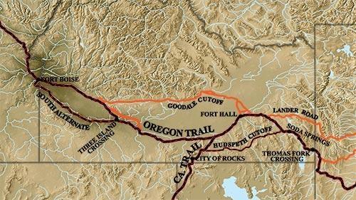
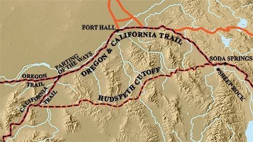
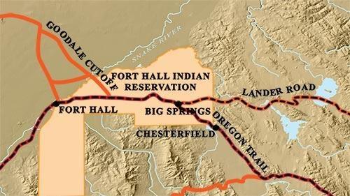
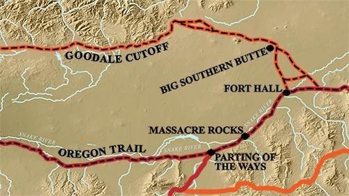
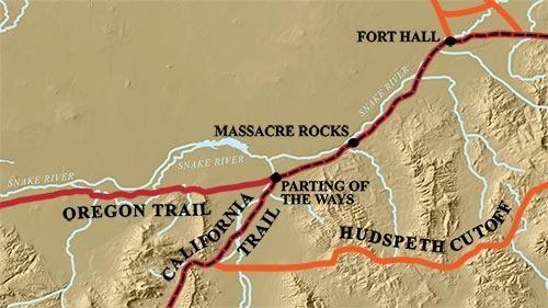
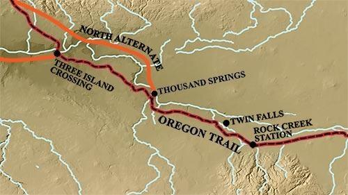
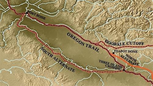
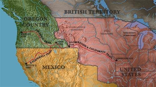
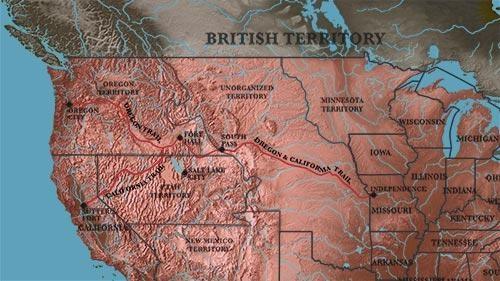
Oregon Trail Links
- The Oregon Trail Bureau of Land Management site
- The Oregon Trail in Idaho – The Idaho State Historical Society
- National Oregon-California Trail Center in Montpelier, Idaho
- Oregon-California Trails Association
- Oregon-California Trails Association Jeffrey/Goodale Wagon Train
- Oregon National Historic Trail—National Park Service site
- Oregon Trail – Bear Lake Scenic Byway
- Massacre Rocks State Park website
- Rock Creek Station - Idaho State Historical Society site
- Thousand Springs State Park website
- City of Rocks National Preserve website
- Idaho State University Oregon Trail site (Documentary aired on PBS.)
- General Oregon Trail in Idaho site