Idaho Geology: A Convergence of Wonders
Idaho's landscape is definitely not for the timid. So much of what we appreciate about Idaho is really the product of intense heat and pressure—of irresistible forces meeting immoveable objects.
No wonder the record of human occupation abounds with constant challenges.
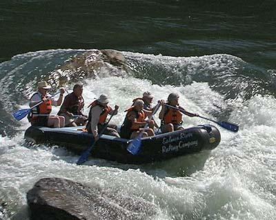
Yet this landscape also beckons us to enjoy. And in that spirit, we'll explore Idaho's rich, complicated and dynamic geology with some of the state's daring recreationists, as we ski the Bruneau Sand Dunes, kayak a Class V section of Succor Creek, descend into lava tubes, climb the City of Rocks and scuba dive in Blue Heart Springs.
And with the help of geologists Bill Bonnichsen and Marty Godchaux, this hour-long "Idaho Geology: A Convergence of Wonders" examines the forces that have inspired and enchanted—and frustrated—every generation.
Idaho Geology, A Convergence of Wonders
The evidence is everywhere; astonishing things have happened to a place we call Idaho.
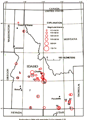
Five Things You Should Know
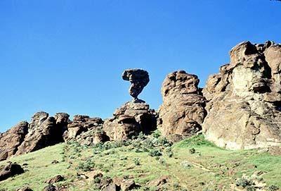
Photos from "Idaho, Home of the Batholith"
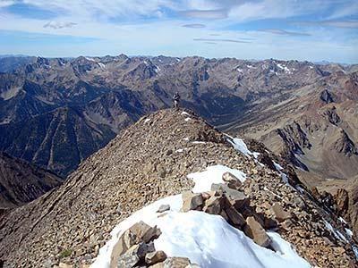
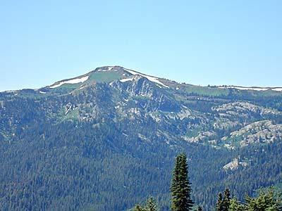
Years ago, there was a bumper sticker that called Idaho the home of the Batholith. It makes a good point and describes what is at the core of central Idaho.
Geologists speak of "provinces" — large areas of land with certain similar features or characteristics — and one of them is the Idaho Batholith province, the amazing heart of rock at the center of the state. The word batholith signifies deep rock. This granite slowly cooled inside the earth rather than on the surface. Then erosion and glaciers exposed and shaped what we see today.
Geologists believe that the earth's crust is formed of moving tectonic plates. And two of them have been on a collision course for several hundred million years. Idaho exists at that point of collision.
Of course there are repercussions when plates collide. The intense friction of colliding plates melted the continental crust under Idaho, turning rock into molten magma. We see the effects here in central Idaho. The super heated rock formed magma blobs, or plutons, that migrated toward the earth's surface. Being less dense than the surrounding rocks, the magma rose like a marshmallow in hot chocolate.
The blobs that made it to the surface erupted as volcanoes. The ones that didn't — that eventually cooled and crystallized five or ten miles below the surface — we call batholiths.
"We have very large batholiths," says geologist Bill Bonnichsen, "like the Idaho batholith that has a southern lobe, the Atlanta lobe, and the northern lobe, the Bitterroot lobe. Then there's another large batholith called the Kaniksu batholith, that's in the core of the Selkirk range."
Geologist Marty Godchaux describes a batholith this way: "Some people think that the batholith is a huge sheet — and I think there's some merit to that — that that granite magma rises up and finds its level of neutral buoyancy, and then stops there as a giant mass and cools. Other people envision a batholith as being almost beehive-shaped, going down into the deepest part of the crust. I think probably there are more geologists now who would favor the sheet — the batholith as a great, thick, irregular sheet — at a zone of neutral buoyancy in the crust."
So there's this mass of molten rock miles deep in the earth that will eventually become the core of Idaho. But before it becomes visible, it needs to rise up. Then, it needs to shed literally miles of earth before we can see it.
Bill Bonnichsen describes it this way: "The magma of granite composition is going to be less dense than the surrounding rocks, and therefore it is going to attempt to rise; and if you've got a big enough volume of it, then there's really nothing going to stop it. It is going to rise up."
"But countering that is loss of heat," he points out. "So, many batholiths get up to a certain level in the crust where there's a balance between the strength of the rocks and the tendency to rise up, and if they crystallize at that depth, they can still have a certain amount of cover over them. In the case of the Idaho batholith, it came up to a certain level, then did its crystallization — let's say 5 to 9 miles in depth."
This cooling-off period occurred 60 to 100 million years ago, depending upon the batholith. So what exactly happens to the miles of material on top of that now-cooled batholith?
"Either part of it just physically slides off, or part of it erodes away," explains Bonnichsen. "In the case of central Idaho, both processes have occurred. All those Paleozoic and older rocks that we see over in east central Idaho, I think, to a considerable degree, just basically slid off of the uplifted zone. It took time and it went in pieces, and there's been erosion, and the Idaho batholith is still eroding. That's why you see canyons and mountains there now. It's got topography like that, which indicates it has been eroding for many, many millions of years. It's in the stage of what you'd call mature topography."
Idaho's batholith could also be called an incubator of precious metals. Gold is what catapulted Idaho into the national spotlight back in the 1860's, thirty years before it became a state.
Early prospectors found gold in stream beds and river gravels. Later they realized gold is associated with rocks formed in those tectonic collision zones directly under Idaho. And it's still a pretty safe bet that you'll find gold along what's called the Trans-Challis fault.
"A lot of the gold in Idaho was originally held in quartz veins associated with the Trans-Challis fault zone," says Bill Bonnichsen. "This is a zone of faults and igneous dikes many miles wide extending southwestward across the state from the Challis-Salmon area toward the old gold camps of Idaho City and Silver City. Why nature chose to concentrate gold along that trend is still a good geologic mystery!"
Text by Bruce Reichert
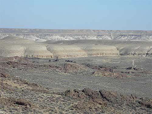
Photos from "Graveyard of Old Volcanoes"
The first written reports from southern Idaho's Snake River plain were not complimentary. To the emigrants on the Oregon Trail, this was a desolate place. In time, this pathway of the pioneers came to be known as the world's longest graveyard.
To geologists who have since studied its mysteries, this immense basalt region is indeed a graveyard, a graveyard of dead volcanoes.
About 16 million years ago somewhere near the Idaho-Oregon-Nevada border, a plume of hot material worked its way up from maybe 50 miles underground. And as it did so, it melted the rocks closer to the surface. These rocks, which were relatively rich in silicon and aluminum, yielded rhyolite magma, which erupted explosively and spewed across the landscape in massive quantities. We catch present-day glimpses of the depth of the outpouring of this pale rock in some of the canyons of Owyhee county.
These large-scale eruptions extend northeastward from that location all the way to the present activity under Yellowstone National Park. Among geologists this is known as the "hot spot" theory. That plume or hot spot has not moved, even though right now it's directly under Yellowstone. Instead, it's the continental plate above the hot spot that has been moving, traveling westward at the speed of fingernail growth. But compound that over 16 million years, and what you have is the Snake River plain . . . in other words, a series of old Yellowstones.
"Just to go back to the basics," explains geologist Marty Godchaux, "it's the only continental plume track on earth today, so it's absolutely unique in that sense." Today, its approximate equivalent might be the oceanic plume track that is creating the Hawaiian Islands.
"Volcanoes have played an enormous role in the evolution of most of this state," says Godchaux, "particularly the volcanism in the Snake River plain that is the result of the so-called Yellowstone plume, or we think that's the best theory. So we have a snapshot in time, of that plume sitting under modern day Yellowstone. What we've done is to look at the ancient Yellowstones, the Yellowstones of five, eight, eleven, thirteen million years ago that stretch back across Idaho to the southwest."
Several popular geology books have argued that it was a meteor striking the earth millions of years ago that wounded the earth's mantle, causing the hot spot that created the Snake River plain. Neither Bill Bonnichsen nor Marty Godchaux buys that theory. "Superficially, it's a really attractive idea," says Bonnichsen, "but if one goes out and looks for specific evidence for that, the evidence is lacking."
He lists some of the missing evidence: the debris fields from the fallback of material that would have been blown into the atmosphere; the lack of shatter cones which occur when an impact hits; the lack of glass melts. "So, personally, I discount the idea. It's an interesting idea, but it's gone to the dust bin of interesting geologic ideas."
Bonnichsen has his own ideas about what started it all. "One of the theories is the 'hot spot' theory, that from somewhere very deep within the earth, some sort of a plume of hot material came up and caused melting in the upper part of the mantle.
"Another theory that has been put forth is that the Snake River plain lies astride a zone of disjuncture within the earth's crust. To me, that idea is a little bit more attractive. And then the process of melting got started at one end of it; and as the process of spreading to the south continued — and this didn't happen to the north — there developed a zone where there was upwelling within the mantle so that melting could occur, and that has progressed across the landscape from southwest to northeast.
"Now, one of the interesting things is that zone of melting lies approximately parallel to the direction in which the North American continent has been advancing across the interior of the earth as the earth's plates move.
"Beyond that, I don't think we have an exact explanation; but we're either looking at a model in which it was just something that started deep within the earth, or we're looking at a model that takes into account the plate motion and the variations of that as the earth's surface has evolved."
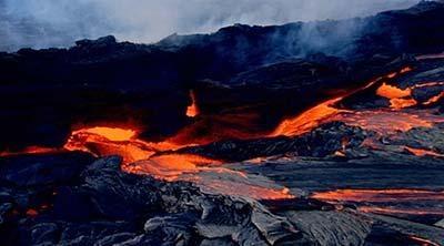
The latest basalt eruptions on the Snake River plain occurred approximately 2,000 years ago, in the Craters of the Moon area. Bonnichsen calls this the latest manifestation of a long term process in southern Idaho of the development of the Snake River Plain. "And in the case of the Craters of the Moon, there is a series of fissures that run across the plain known as the Great Rift; and along that series of fissures, basalt magma came up from deep in the earth's interior, came out on the surface and made a series of vents and a series of lava flows.
"So this is a process that was repeated several times in recent geologic history. The people who work here have determined ages of several of the flows. About every 2,000 years for the last 15,000 years there have been a series of basalt flows that came out and have built up the lava flows and the vents in the Craters of the Moon area."
It's not too far-fetched to imagine Craters of the Moon erupting again, much as Kilauea in Hawaii is doing now. "Both are fundamentally driven by the heat escaping from the interior of the earth," explains Marty Godchaux. "Heat is the engine that drives the earth. We geologists, those of us who consider ourselves volcanologists, are just waiting and hoping that maybe, maybe in our lifetimes, Craters of the Moon will see another basaltic eruption. It's not a given, but we're hoping."
We asked Bill Bonnichsen what some of the popular misconceptions are of this part of the state. "Many people see some rather drab, flat areas of sage brush and believe it's a dull place, and it really isn't. It's scenically interesting and geologically really quite interesting.
"Second, people think that a large volume of the Snake River is basalt. That's untrue. If you were to drill holes out in the middle of the plain, you'd find you went through a few hundred feet of basalt; then you would go into rhyolite, and that might be thousands of feet thick. So the volume of rhyolite in the evolution of the Snake River plain is much larger than the volume of basalt. It's just largely hidden or off to the sides. So those are a couple misconceptions."
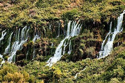
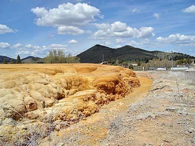
Under the eastern Snake River plain is an aquifer that covers as much area as one of America's great lakes, Lake Erie. However, it holds considerably less water than Lake Erie because the water is stored in the cracks and crevices of the basalt flows that fill the eastern plain.
Pioneers on the Oregon Trail stopped at what they called Thousand Springs. It was a magical place to them, more so because they did not understand where all that water was coming from. Now we know.
"The present canyon of the Snake River, starting about Niagara Springs and Thousand Springs is at the lowest point of those porous basalts. The river is cut down deep enough to intersect the water table, so water just gushes out," explains Bonnichsen.
The aquifer flows mainly southwest, draining to the Snake River. The water at Thousand Springs comes from as far away as the southern end of Yellowstone National Park two hundred miles away, and from the Lost Rivers near Mackay, which flow into the Snake River plain and then just disappear into the basalt. Put a thermometer to this water, and it will read a constant 58 degrees.
Scientists are still mapping this underworld, but they do know that in some places, such as south of the Snake river near Twin Falls and Buhl, the aquifer is thin and not as robust as people once assumed.
"If you get into the lower reaches of the basalts, they get pretty tight. They don't have near as many fractures in them," says Bonnichsen. "The transmissible part of the flows is only about 100 feet thick. Below that the flows are very dense, and they won't transmit water."
Geologists differentiate between this eastern Snake River plain aquifer and other aquifers, like the one near Boise, or the Rathdrum prairie, both of which are filled with gravels. Because the eastern plain is a fracture controlled aquifer, it's more vulnerable to contamination.
Farmers have been drilling wells into this vast aquifer since the 1950's, allowing more land to be cultivated. But the groundwater and surface waters are intricately connected, in ways we are still discovering, "which says that we should be more careful with our aquifer than we have been in the past," says Bonnichsen, "because it has just been mined, and the assumption has been made by many that it is just infinite, which is really not true."
Text by Bruce Reichert
Photos from "Earthquake Zone of Basin & Range"
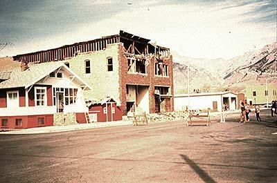
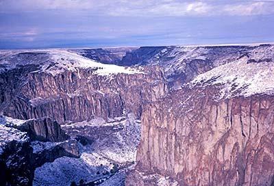
Had you been on top of Mt. Borah on October 28, 1983, around 8 a.m., you would have suddenly found yourself a good eight inches higher. The earthquake, a ground-rupturing magnitude 7, also lowered the nearby valley floor by several feet, creating a 21 mile long gash, or fault scarp, along the edge of the mountain range.
That it happened near the Lost River Range is no surprise to geologists. This is part of what's called the Basin and Range Province, all the proof you need that we are living atop an unpredictable landscape shaped by forces outside our control.
The Basin and Range Province covers a good chunk of the West. One geologist described the unique topography of narrow parallel mountain ranges as an "army of caterpillars marching toward Mexico." Idaho has its own set of caterpillars.
The Lost River Range runs basically north and south. Parallel to that range is the Lemhi Range; and parallel to that range is the Beaverhead Range. While most mountains are eroding away, these mountains are still growing. That's because tectonic forces are breaking this part of the world up into blocks, stretching the continent east and west.
This is Idaho's earthquake zone, one of the most active earthquake zones in North America.
Geologist Marty Godchaux explained the geologic process of Basin and Range this way, using the Lost River Range as an example. "Every block that sinks due to stretching has a small range on one side where that rotated block is tilted up a bit; that would be the White Knob Mountains. Then on the other side, we have a great fault scarp and imposing high mountains such as Borah Peak; and a flat, absolutely flat valley floor in between, where the erosional debris pours in and makes a flat elongated valley floor."
And why does this lead to earthquakes? "The major earthquakes that we might expect now would be the type that the Borah earthquake was, what we call dip-slip. In other words, they result from tension in the earth's crust pulling the crust apart slightly. Rock is going to accumulate some elastic strain. They are like elastic or a sling shot, so they can be stretched. Every rock has its breaking point, and when it breaks, that's when you have an earthquake."
Godchaux believes there will be more earthquakes like the 1983 earthquake that will raise the Lost River Range slightly higher and drop the valley floor slightly lower.
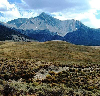
The breaking and bending of rocks continues southeast of Mt. Borah, along the Idaho-Wyoming border. The Teton Range is the youngest of the Rocky Mountains; in fact, it's one of the youngest mountain ranges in the world. But at its core are some of the oldest rocks in North America. Here you can see all the different rock types piled on top of each other: the sedimentary, adjacent to the fire-created igneous, next to the pressure-treated metamorphic rocks.
They all look solid enough, but these mountains are under enormous stress deep within the earth. In fact, they are still growing, in some places a foot every hundred years. And as fast as they are rising, glacial ice and snow and rain are eroding them away, creating surfaces that perhaps only mountaineers can truly appreciate.
Small earthquakes are a regular occurrence here. Almost every day seismic instruments record earthquakes up to magnitude 5 in the Teton-Yellowstone region. And the last big one with fatalities was in 1959, when twenty eight people perished.
You might ask yourself, why does eastern Idaho have more earthquakes than, say, northern Idaho? And part of the answer may be that the Snake River plain seems to be some great crustal dividing line between the extended basin ranges to the south and the less extended ranges to the north.
"Much of the action in the present day is the stretching of the Basin and Range Province," explains Godchaux. "And so if you're along the eastern edge of the Basin and Range Province, or in the seismic bow wave around Yellowstone, that's where the earthquakes are most likely to happen. The historic earthquakes have happened because Basin and Range extension tends to move eastward through time. In other words, in the early tertiary Basin and Range extension, the focus of it was further west. It's as if every time you try to stretch the North American continent, you bite off another piece, and the zone of maximum activity now is along the Wasatch front. That's kind of the eastern limit of Basin and Range extension, but only at the present time. So the zone of southern and eastern Idaho is more likely to get earthquakes because it's in the intermountain seismic zone."
People are always surprised to hear that climbers find marine life on the top of Idaho's highest mountain, Mt. Borah. So we asked geologist Bill Bonnichsen how that could be.
"I think that's a great question. You have to look at the succession of geologic events that brought that about. In the first place, you had to have an ocean wherever those sediments were deposited; and it was somewhere in the Idaho vicinity and perhaps a little bit west of where Mount Borah is today. So there was an ocean, and there were animals in the ocean, and their remains got trapped in the sediments.
"And then later in time, nature assembled the state of Idaho. There was a push from the west as a large micro-continent crashed into the side of North America, bringing an end to the ocean basin at that time; and this also brought about raising up of the landscape. This would have been during the period of time we call the Mesozoic.
"And accompanying that, but probably happening just a little bit later, was the development of the Idaho batholith. As material is brought down underneath the edge of the continent by subduction, part of that material melted, came up into the earth's crust, melted more material and developed this large, massive but very viscous, body of granite we call the Idaho batholith. The effect of that was to raise the landscape up even higher, including the Paleozoic sediments that were already sitting there.
"That situation of an area being raised very high permitted these layered rocks at the top to slide off. A lot of them slid toward the east to make what is called the thrust belt. You've got a series of sheets that slid off one after the other from a position a little bit further west, and they took the fossils with them of course.
"And then even later in time, we had block faulting — the very large, fairly steep faults that gave rise to the Lost River Range and the Lemhi Range and the Beaverhead Range. And it's those last faults that really pumped the fossil bearing beds up to their present elevation, where we're 12,000 feet above sea level.
"So, there's a succession of events. You had to have the ocean there at one time; then you had to bring in the micro-continent; then you had to have the development of the batholith; then you had to have the thrusting and gravity slides; and then you had to have the block faulting. What's that, five successive events to bring that about."
The mountains of the Basin and Range remind us of the words of historian Will Durant: "Civilization exists by geological consent, subject to change without notice."
Text by Bruce Reichert
Photos from "Mega-Floods of the Recent Past"
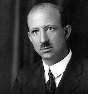
So much of geology is detective work. In the 1920's a young geologist, J Harlen Bretz, put forth an outrageous theory. He wrote that a monster flood of biblical proportions had torn across northern Idaho and into eastern Washington, dramatically altering the landscape.
He received a lot of ridicule for his views, but eventually, most geologists came to accept the evidence. Later, they accepted the notion that, along the Clark Fork River, an ice dam several thousand feet high had forced water to back up into present-day Montana.
"It would have measured thousands of feet thick and several miles long," says geologist Bill Bonnichsen. "And this caused the development of a lake in the Missoula valley of Montana. And this lake just filled up and filled up and filled up. And then for some reason — whether it caused the dam to float up, or whether it burrowed underneath the ice dam, it eventually let go with a huge deluge of water."
That deluge tore apart everything in its path. Even mountains were not spared. The top speed of the water is estimated at 70 to 80 miles an hour. For two days, it flowed at a rate of 500 million cubic feet per second, or ten times the flow of all the rivers in the world combined.
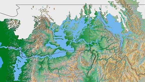
And this Missoula Flood did not happen just once. "This process happened many, many times," said Bonnichsen. "Some estimates are as high as 80 times; others are like 30 times. We don't know exactly how many, but there were many successive Missoula floods, and in the process of the ice coursing through the valley where lake Pend Oreille is, it dug deeper and deeper, leading to a lake that is on the order of 1,200 to 1,500 feet deep.
"That's the cause of Lake Pend Oreille. When that process was all done, here was this deep basin that the glaciers had dug out. And where the glacier terminus had been is where the Rathdrum Prairie is. That is then filled in with material, so the lake has been impounded ever since."
Today there are no glaciers left in Idaho, so it's hard to comprehend just how heavy an ice field can be. We have to travel to Alaska for any comparisons. But the weight of a great thickness of ice can push the earth's surface down hundreds of feet.
"And you can see some really interesting effects of that in the drainages of the rivers in northern Idaho and on up into Canada. At one time all that stuff had to flow south and now all of those rivers flow north as the southern part came up. And as near as I can figure out, a lot of that has to do with the isostatic rebound of the land as the continental glaciers were receding with time."
The last Missoula flood swept through northern Idaho a mere 15,000 years ago, burying parts of Oregon and Washington in hundreds of feet of water. So it is conceivable that someone actually witnessed the greatest flood ever documented by scientists.
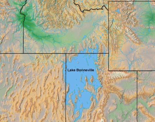
About the same time as floods were tearing through northern Idaho, a great cataclysm was brewing in southern Idaho. Water was backing up in Utah, nearly a thousand feet above the current level of the Great Salt Lake. At Red Rock Pass, southeast of Pocatello, the rupture occurred. Four hundred foot flood waters tore through the Portneuf Narrows. In other places the deluge broke free across the plain.
"When the Bonneville flood entered the area where American falls reservoir is, it went out into a fairly flat area," explains Bonnichsen, "so there's a large delta of material deposited there — the American Falls delta — which is a relic from the time of the Bonneville flood."
Further west the flood followed the path already established by the Snake River, spilling out above the canyon rim. "And it's almost like a mud flow down at the bottom of a channel like that. It has great erosive capability," said Bonnichsen.
It must have been an amazing sound. Boulders the size of cabins, being ripped from the canyon walls, bumping and grinding along the river bottom, carried along by the incredible force of the flood.
"One of the interesting things you find are great big sandbars or gravel bars," says Bonnichsen. "They're really boulder bars, just like you would see in a river, but they're much larger in size, made out of boulders, boulders as much as ten feet across."
Huge blocks of basalt traveled three to six miles before eventually coming to rest high above the river. Now considerably more rounded, their resemblance to petrified watermelons caused one geologist to refer to them as melon gravel. Most of us consider them just one more example of the intensity of the Bonneville Flood.
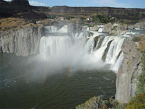
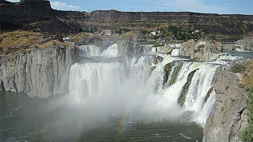
Shoshone Falls, one of the great spectacles of North America, is another example of the power of that flood. It carved the canyon much deeper as the waterfall migrated upstream to its present location, where it is 212 feet high, forty feet higher than Niagara Falls.
Eventually, the flood waters receded, and life returned to normal for the Snake River canyon and southern Idaho. But what is normal, when you're talking eons of time? The ice age that had stretched over two million years was coming to an end. Another climate change was in the works, as ice melted and lakes and swamps and gullies dried up, leaving beds of silt and sand at the mercy of the wind.
For those who wonder which came first, the Bonneville flood or the Missoula floods, Bonnichsen has this to say. "Lewiston is the one place in the state where you really see the overlapping deposits from both the Bonneville flood, which came down the Snake River, and the results of the Missoula flood, which came across northern Idaho and then across central Washington. Evidence has been found in this area that the Bonneville flood came through early on, and the successive Missoula floods affected this area after that."
For modern-day humans, it's interesting to know that these floods were all fairly recent — almost yesterday, in geologic terms — and that we can still clearly see their effects on the landscape, with just a bit of effort on our part.
Text by Bruce Reichert
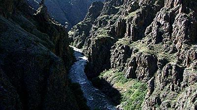
Photos from "Strange Course of Idaho's Rivers"
If we could trace the history of a river over time, we might better understand the clutter and chaos of our wild geology. Each bend, each change of direction signifies a challenge that the river had to overcome on its way to the ocean. And Idaho's two main rivers — the Snake and the Salmon — have faced a multitude of challenges!
The Snake currently flows east to west across the entire southern portion of the state, before turning north into Hells Canyon, on its way to the Columbia and the Pacific Ocean. But there's a complicated story waiting to be told about this relatively young river.
"The evolution of the Snake River is a very complex thing, and it changed markedly through time," says Bill Bonnichsen. "The Snake River is a collage of many parts of many pre-existing rivers, and it's been integrated only in the last few hundred thousand years into its present form. You can look at certain parts of it, and you can deduce that the water had run in the opposite direction at times. And there are people who propose that somewhat earlier in eastern Idaho there were rivers that ran from north to south across that direction that have nothing to do with the present Snake River drainage."
Take Hells Canyon, for example. It's hard to imagine a Hells Canyon without the Snake River coursing through it. This is one of the deepest river gorges in the world — much deeper than the Grand Canyon — and every Idahoan has grown up believing that the Snake is the primary reason.
But the evidence suggests that the Snake is a relative newcomer to this canyon, and that at one time, Hells Canyon waters actually flowed south, not north. "And the evidence for that is, if you look at all the tributaries to the Snake River in the southern part of Hells Canyon," says Bonnichsen, "they actually are flowing toward the south, and the whole thing was going to the south.
"At that time Lake Idaho likely drained in some other direction, rather than through Hells Canyon, because Hells Canyon had yet to be cut to its present depth. In fact, part of the course of what became the Snake River, in the upper reaches of Hells Canyon, likely flowed south into Lake Idaho, as indicated by how many of the Snake's tributaries in that area branch in a way suggesting that flowage was to the south. At that time, those millions of years ago, the outlet of Lake Idaho was in some other direction, not down the present course of Hells Canyon."
In time, the river did find a way to drain massive Lake Idaho through Hells Canyon, and the cutting down through rock commenced in earnest about two million years ago. The Bonneville flood, which occurred about 15,000 years ago, didn't do much to deepen the river, but it certainly widened it. You can see the effects of that one-time deluge in the broad terraces and the gravel bars, hundreds of feet above the present level of the river.
With each passing year, the Snake is deepening Hells Canyon; but since the dams were installed, it's not doing it nearly as quickly. That's because the dams restrict the abrasive sediments that give water such a potent advantage over rock.
"Once the drainage down the course of Hells Canyon was established, erosion took over, cutting the canyon deeper and deeper. This went on for a few million years, eventually leading to the complete draining away of Lake Idaho, lowering of the base level in the southwest Idaho region so that other canyons, such as those of the Bruneau and Owyhee Rivers, could be excavated, and the downcutting of Hells Canyon to its incredible depth as the deepest gorge in North America could take place."
Every rafter knows how quickly a log jam or a new rapid can alter a river, or a well-planned vacation. Now try to imagine what a lava flow or an uplifted mountain can do. That's why Idaho's undammed masterpiece, the Salmon River, travels in every direction of the compass — east, north, west, and south.
"The Salmon River has a very tortuous course," says Bonnichsen. "When the Columbia river basalt was erupted just a few million years ago, it was flowing from east to west. Here come the basalts, packed in against it. It dammed it up so now the river has a right angle bend at Riggins and goes all around like that and goes into the Snake."
Geologists suggest that, before nature conspired against it, the Salmon was likely Idaho's main river, with the much shorter Snake River a tributary to the River of No Return. "Yes, I think that for a while, millions of years ago, the ancestral Snake River was a tributary to the Salmon. But the Snake of that time was much shorter and less voluminous than the present Snake River," explains Bonnichsen. "Now, because it has gotten larger and larger through time, the Snake is the main river and the Salmon is its principal tributary, even though it started out that the ancestral Snake was a minor tributary of the Salmon."
Text by Bruce Reichert
The Geologists' Corner
Photos from "Secrets of the Snake River Plain Revealed"
The Snake River Plain is a recent chapter of Idaho's geological story. It started about 16 million years ago, just after the major pulse of Columbia River basalt volcanism. The first part of Snake River Plain development was not even in the Snake River Plain, but in the Owyhee Plateau area where Idaho, Oregon and Nevada meet. There, massive volcanism commenced as the Yellowstone hot spot began to develop. As time passed and North America moved southwestward, the hot spot cut a swath across southern Idaho and into the northwest corner of Wyoming, where the most recent massive volcanism occurred, less than a million years ago. During the continent's trip over the hot spot, an adjacent zone developed as the Earth's crust was pulled apart, forming a large topographic depression. This became the western Snake River Plain, and for a long time it held a giant lake, which geologists have named Lake Idaho.
Two fundamental types of volcanism were involved in the formation of the Owyhee Plateau and the Snake River Plain, as the wave of volcanism swept across southern Idaho. The first was the eruption of rhyolite from magmas with the same composition as granite, being rich in silica and alkali elements. These magmas mainly were materials melted out of the Earth's crust, so its no wonder they have a granitic composition. The other type of volcanism was the eruption of basalt. These magmas came from deeper in the Earth, from the region geologists call the mantle, and were hotter than the rhyolite magmas. Basalt is much richer in iron and magnesium and poorer in silica than rhyolite.
Besides the volcanism, the deposition of sediments in the western Snake River Plain during the existence of Lake Idaho, and the cutting of canyons after it had drained were two major events occurring as the Snake River Plain landscape evolved. The final episode impacting the landscape along the Snake River was the Bonneville Flood. When Utah's Lake Bonneville overflowed about 17,500 years ago, the deluge swept along the course of the river and modified the landscape in many interesting ways in its wake.
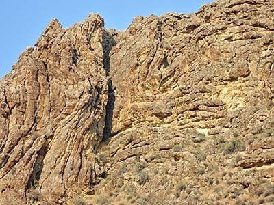
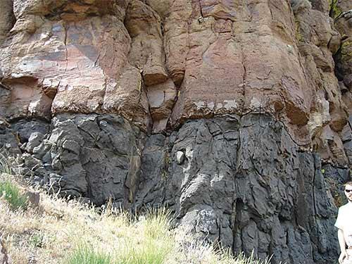
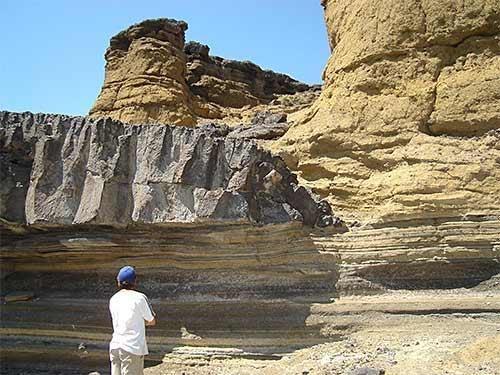
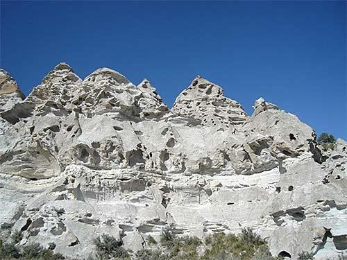
Blackrock Escarpment: Several welded tuff layers are magnificently exposed in this 1500-foot-high cliff in Bruneau Canyon near the Nevada border. Each layer is rhyolite that erupted explosively from the Bruneau-Jarbidge region, an early active portion of the Yellowstone hot spot. The layers range from 12.7 million years old at the base of the sequence to 10.3 million at the top. They make up the Cougar Point tuff, a volcanic unit widely distributed along the margins of the central Snake River Plain. In a geologic instant some of these enormous explosions erupted many hundreds of cubic miles of rhyolite magma as tiny molten particles that sped across the land buoyed up by hot gasses, blanketing areas more that 100 miles across. Welded tuff layers like these are believed to lie beneath much of the Snake River Plain and Owyhee Plateau.
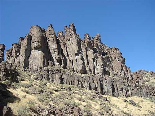
Balanced Rock Rhyolite: There are many rhyolite lava flows, like the 8-million-year-old Balanced Rock flow near Castleford, within the Snake River Plain and Owyhee Plateau. Most are younger than the huge welded tuff layers, but are older than most of the basalt flows. These lavas form from rhyolite magmas with very low gas contents that just oozed out of the earth rather than erupting explosively. Low gas contents make rhyolite magmas very viscous, so they form flows that may be hundreds of feet thick and take years to cool. As they cool, prominent vertical fractures form in their interiors which, when exposed in canyon walls, typically guide the development of large vertical pillars.
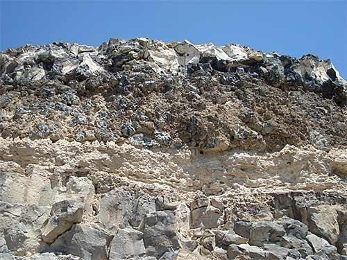
Basal Vitrophyre: Due to its chemical makeup rhyolite magma not only is viscous but also is slow to crystallize when cooled. This leads to the situation seen at the base of most rhyolite bodies, both welded tuff layers and rhyolite lava flows, where the most rapidly cooled bottom material didn't have a chance to crystallize, but remained in a glassy state. This glassy form of rhyolite, called vitrophyre by geologists, is black in color, in sharp contrast to more slowly cooled interior parts of rhyolite sheets that did crystallize and which typically are brown to red in color. Thus, even with the strong color contrast, both parts of a unit, like the one in this photo, formed at the same time from the same magma batch.
Shoshone Falls: This beautiful waterfall on the Snake River is carved into the upper part of the 6-million-year-old Shoshone Falls rhyolite lava flow. A nearby drill hole indicates the flow to be about 600 feet thick. This waterfall will be sustained for a long time because rhyolite is very hard and resistant to erosion, in contrast to the overlying, thin and pervasively jointed basalt flows from which blocks readily are broken out by natural processes. Shoshone Falls likely was developed into its present form during the Bonneville Flood, about 17,500 years ago, and has not changed much since then.
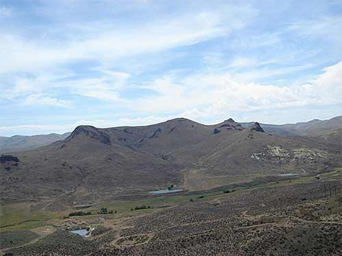
Buck Mountain Volcano: About 11.6 million years ago this small rhyolite volcano, in the Owyhee Mountains south of Homedale, was built during one of the eruptions that led to the formation of the Jump Creek rhyolite. In this view one is looking into the volcano's crater area. A small rhyolite lava flow was extruded from the volcano, whereas the volcano's slopes are an accumulation of small blobs of spatter that coalesced into the original conical form. When only small volumes of rhyolitic magma are erupted small volcanoes like Buck Mountain are built, whereas large volumes of rhyolitic magma typically erupt through long fissures along which the surface subsides to form calderas.
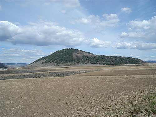
China Hat Dome: China Hat, a geologically young landmark near Soda Springs in the Blackfoot lava field, stands nearly 1000 feet high and is 1.4 miles long. It formed during a small rhyolite eruption only about 57,000 years ago, and is the largest of three domes lined up above a buried fissure that fed magma to the surface. The rhyolite magma was so viscous it couldn't flow away from the vent; it just accumulated in a big pile. Since the volcanic activity in the Blackfoot lava field was so recent, the area is of considerable interest for geothermal energy. Domes similar to China Hat are a common type of volcanic landform that are built where small batches of viscous magma erupt.
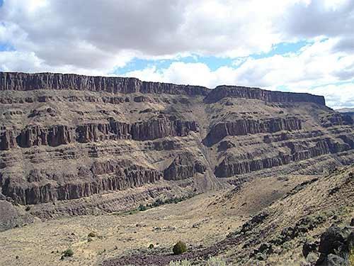
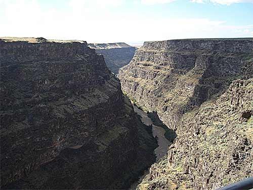
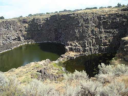
Bruneau Canyon: Bruneau Canyon is about 800 feet deep and only a few hundred feet wider at this scenic viewpoint south of Bruneau. The river rapidly cut down through many layers of basalt, ranging from 7 or 8 million years old at the bottom to 4 or 5 million years old at the canyon rim, as Lake Idaho drained away and afterwards. Once the lake was drained, the river's base level became much lower; previously the high lake level had prevented the river from cutting down through the basalt.
Basaltic Tuff: About a million years ago, just after Lake Idaho had drained away, the near-lake region may have been swampy and certainly had a high groundwater table. When basalt magma rose into this wet environment, as happened many places in the western Snake River Plain, large amounts of steam formed and erupted explosively, blowing out fragments of the basalt magma and the surrounding lake sediments. Such explosions are called phreatomagmatic eruptions; from them are deposited colorful layers of tuff like the ones illustrated from along the Snake River near Grand View. Also shown is the end of a thin basalt flow that was deposited during the phreatomagmatic eruptions. The thinness of this flow shows the basalt lava was very fluid, in contrast to the extreme stiffness of rhyolite lavas that permit only very thick flows to form.
Pillow Basalt: When a basalt flow runs into a lake or river it commonly breaks up into small blobs of lava, typically from a few inches to a few feet across, which cool rapidly into partly glassy basalt. Geologists call these rounded lava blobs pillows. The pillow basalt layer shown in the photo is in the Jerome Golf Course basalt flow, exposed at the Snake River Canyon rim a few miles downstream from Perrine Bridge. These pillows were formed tens of thousands of years ago when the basalt flow, which was spreading northward, ran into the Snake River. Clearly this happened before the river had eroded its canyon, since the layer of pillows is at the canyon rim. Pillow basalts occur at many other places in the Snake River Plain, especially where Lake Idaho once stood.
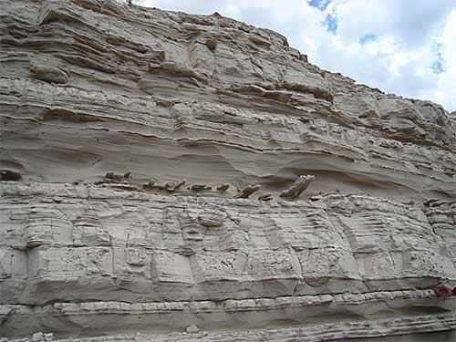
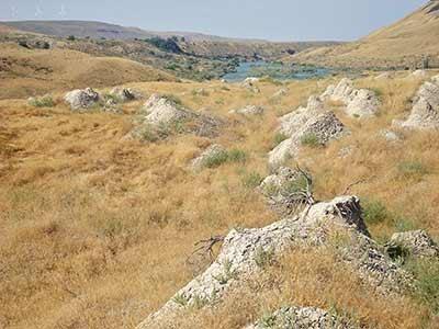
Glenns Ferry Formation: Layers of sand, interbedded with silt and sometimes gravel, commonly are deposited near the margins of large lakes, such as Lake Idaho. In this photo, taken a few miles south of Bruneau, the near-shore deposits of Lake Idaho are part of the Glenns Ferry formation. These sediments were deposited in the lake during the latter part of its existence, from about 6 to 2 million years ago. The curious elongate structures sticking out of the sand layer in the middle of the photo are concretions, in which the sand has been cemented by minerals from the groundwater. The elongation of these concretions likely indicates the direction water was flowing through the sand.
Chalk Hills Formation: Typically, at locations far from shore out in the middle of large lakes, silt and clay, as well as volcanic ash that falls from the sky, are deposited in fairly uniform layers. Such is the case for the sediments shown in this photo of a locality south of Oreana. These layers are part of the Chalk Hills formation and were deposited during the earlier part of Lake Idaho's existence, probably between about 10 and 6 million years ago. The rocks in the photo's foreground are at the top of a 10- to12-million-year-old rhyolite lava flow, from which the sediments were eroded after the lake was drained.
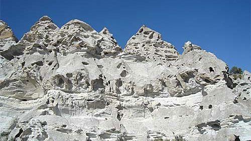
Teepee Rocks: These hoodoos, which resemble a row of teepees or an assembly of giant garden gnomes, are carved in a thick layer of volcanic ash known as the tuff of Ibex Peak exposed along Trapper Creek, southwest of Oakley. This ash accumulation, which in places is hundreds of feet thick, collected in a lake system along the Idaho-Utah border area between about 17 and 10 million years ago. The ash came from numerous large caldera-forming rhyolite eruptions at various places in the Owyhee Plateau and Snake River Plain in the early stages of the development of the Yellowstone hot spot. The holes in the teepees are the result of freeze/thaw action and wind erosion.
Plunge Pools: During the Bonneville Flood large volumes of water poured into Snake River Canyon in the area upstream from the city of Twin Falls, eroding out and enlarging the canyon in the process. In this photo taken at the canyon rim near Dierkes Lake, one can see little plunge pools that were excavated in the basalt by water falling over the canyon rim, and tearing out blocks of basalt in the process. The pools now are spring-fed because irrigation has led to a shallow water table in that area.
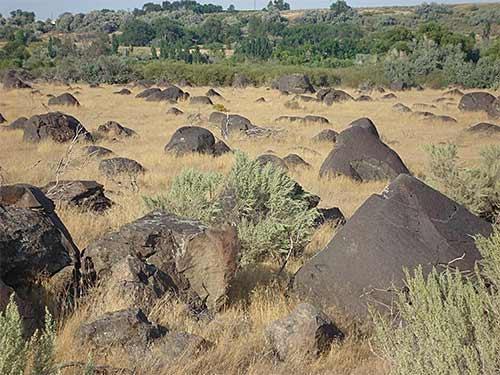
Melon Gravel: During the Bonneville Flood, blocks of basalt, some larger than 10 feet across, bounced along the bottom of the flood channel, continually bumping into one another. The blocks became partially rounded in the process, and when guided by the flood into areas where the water velocity was lower, accumulated into large bars, similar to gravel bars in normal rivers, but of a much larger scale. These partly rounded boulders, located in a field near Hagerman, are a good example of the Melon Gravel, which is the name geologists have used for these flood deposits. This bar contains basalt boulders from many different basalt flows exposed upstream in the walls of Snake River Canyon.
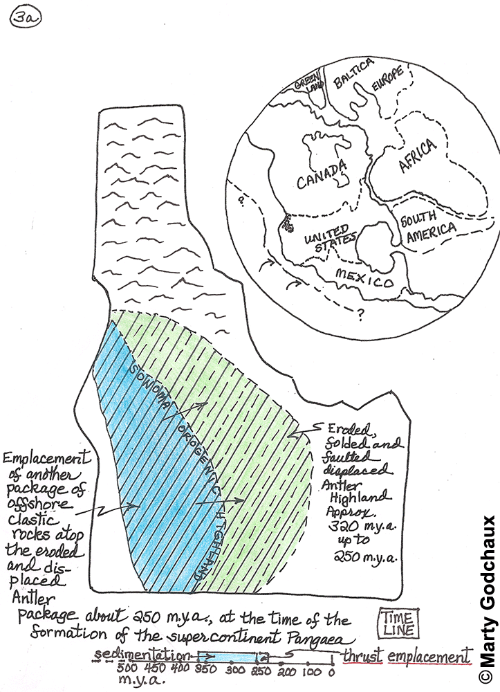
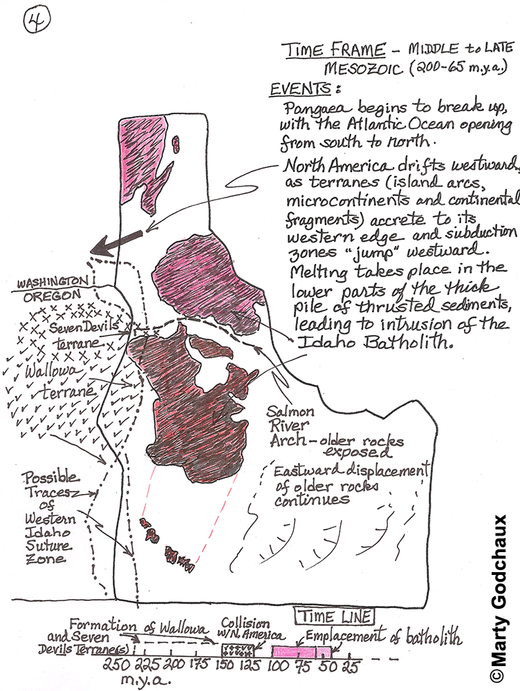
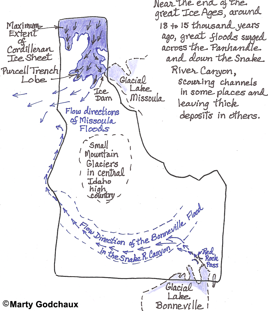
Paleogeologic Maps of Idaho - see images in Episode Gallery
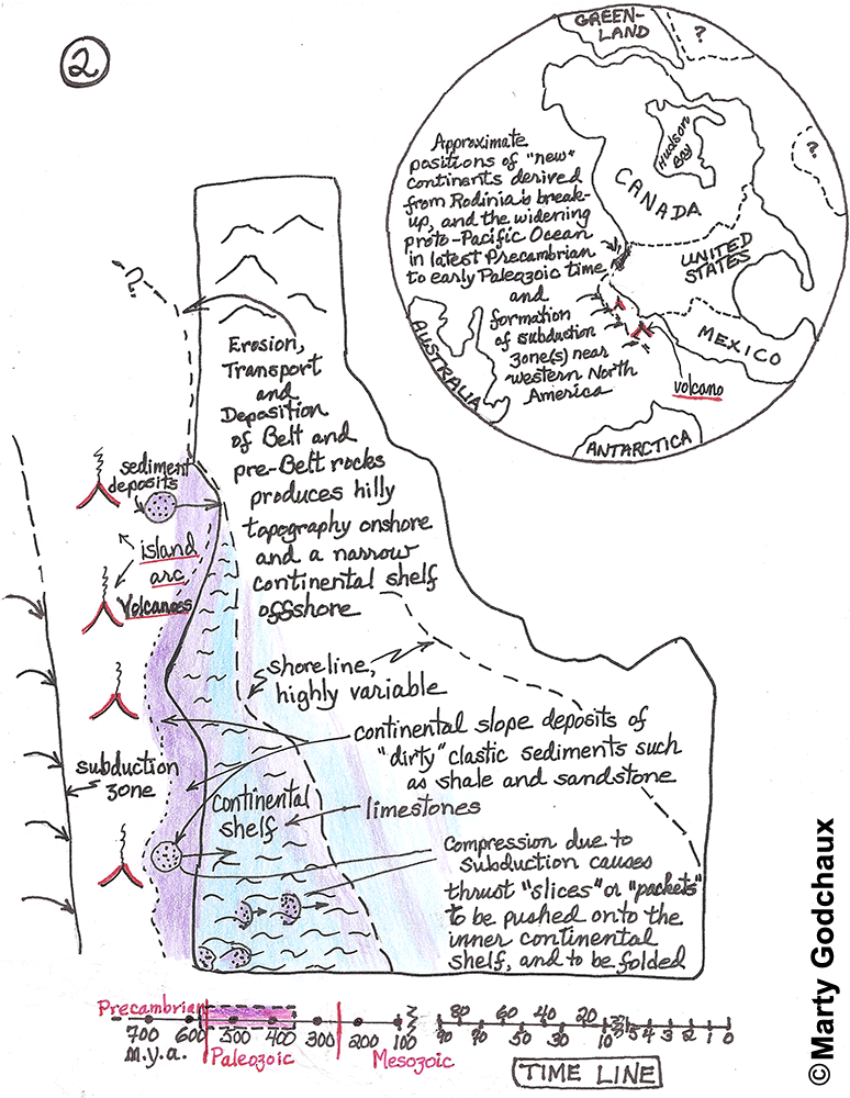
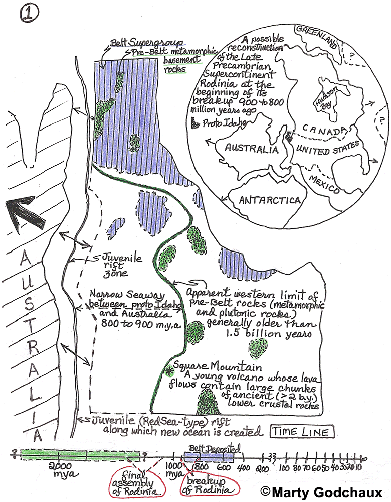
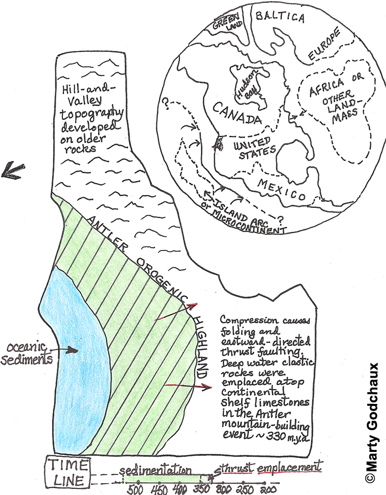
This set of sketch maps illustrates what geologists think Idaho might have looked like during various time intervals in the past two billion years of Earth history. Needless to say, our knowledge is less precise for the most ancient configurations than for the most recent ones.
The first four maps (numbered 1, 2, 3 and 3a) include speculative global reconstructions that illustrate the probable tectonic settings of "proto-Idaho" and its relationship to times of formation and breakup of supercontinents Rodinia (Late Precambrian) and Pangaea (Early Mesozoic).
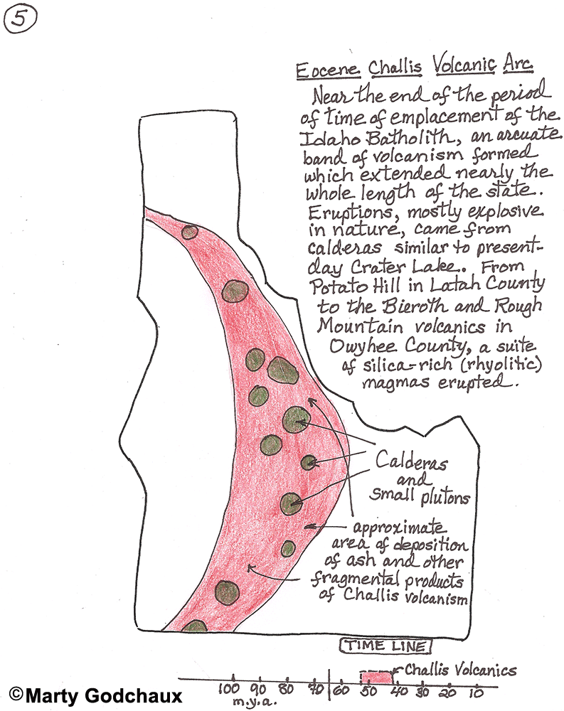
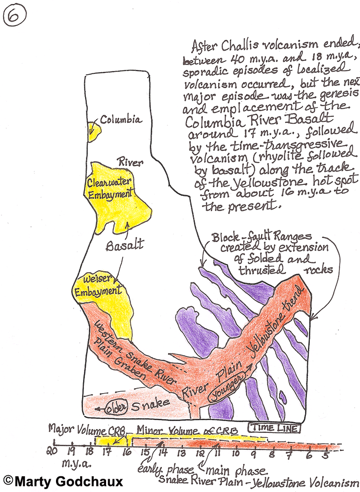
The final four maps (numbered 4, 5, 6 and 7) concentrate on Idaho alone. By the Late Mesozoic, roughly 100 million years ago (m.y.a.), proto-Oregon and proto-Washington had already been added to North America, and Idaho no longer had a Pacific coast. Accretion of the Wallowa and Seven Devils terranes caused folding and thickening of the older rocks and triggered large-scale melting in the middle and lower crust and emplacement of the Idaho Batholith. Continued subduction of oceanic plates to the west fueled the explosive eruptions along the Challis Arc, beginning around 50 m.y.a. in the north and getting progressively younger, to less than 40 m.y.a., near the Nevada border. The rise of the Yellowstone mantle plume triggered the Columbia River Basalt eruptions and the immediately following rhyolitic explosions and subsequent basaltic effusions along the Snake River Plain - Yellowstone trend.
These also are time-transgressive, beginning about 16 m.y.a. near the Idaho-Oregon-Nevada junction and continuing to present-day Yellowstone as North America moved slowly westward over the plume. Continental-scale extension occurred in about the same pattern at the same time, and may also be related to the plume. It produced the Basin-Range Province, which extends all the way from central and eastern Idaho to the trans-Mexican Volcanic Belt. The final set of landscape-modifying events included the incision by major rivers of deep canyons and the inundation of the northern and southern regions of the state by the enormous post-glacial Missoula and Bonneville Floods.
Photos from "The Future That Awaits Idaho"
In 1788, one of the world's first geologists, Scotsman James Hutton, proposed the Principal of Uniformity, or uniformitarianism, which was expressed in 1830 by another early geologist, Englishman Charles Lyell, as the well-known phrase: "The present is the key to the past." To peer into Idaho's geologic future we can rearrange this thinking into: "Our geologic past predicts our geologic future," or "What has gone around might come around again."
Things that might happen in the next few thousand to hundreds of thousands of years
1. Climate Change: In the near-term Idaho may get hotter and stormier as greenhouse gases accumulate in the atmosphere, leading to more erosion when rivers flood. But, it is likely that within the next hundred thousand years — as has occurred several times in the last couple of million years — continental glaciation may return, covering the northern half of North America and high mountain ranges in ice. This would include a colder and wetter climate, with increased erosion and perhaps even the return of such features as Lake Missoula and periodic massive floods if ice dams are breached.
2. Volcanism: Certainly there will be more basaltic lava eruptions in the Snake River Plain region. If some occur in areas where the ground-water table is shallow or in streams, they could be quite explosive and form tuff cones hundreds of feet high or even maars (volcanic explosion craters) as much as a mile across.
3. Land subsidence in the eastern Snake River Plain region: The area around Idaho Falls, Rexburg, and Ashton will continue to sink slowly as it has for the last million years or so, as the Earth's upper crust cools following the passage of the Yellowstone Hotspot topographic bulge. The surface in that region would likely get as low as around Burley and Twin Falls, farther west. Such subsidence might lead to the formation of lakes and meandering about of rivers and streams.
4. Strong earthquakes, valley subsidence, and mountain-range uplift: As the Basin and Range Province continues to become wider because of crustal stretching we can expect these things to occur. Such activity will be especially prevalent in easternmost Idaho where the current seismic activity is concentrated, and perhaps even farther east as the province continues to get wider.
Things that might happen in the next few million to tens of millions of years
1. The Yellowstone Hotspot may move eastward and bring about more gigantic explosive eruptions of rhyolitic magma and the collapse of more huge calderas.
2. Erosion will continue so that in central and northern Idaho the canyons get wider and deeper and the mountains gradually wear away; and in southern Idaho the volcanic plateau will be replaced by valleys and hills as the canyons become wider and wider and eventually merge with one another.
3. The widening of the Basin and Range Province might become so pronounced that the Gulf of California extends northward as far as Idaho, letting the ocean flood part of the state.
4. The Baja California peninsula and slices from the west side of California may drift northward along the San Andreas fault or future strike-slip earthquake faults, adding to Oregon and Washington and changing Idaho's climate and drainages, and perhaps even causing compressive deformation of the Earth's crust, leading to the development of new mountain ranges and volcanism as far east as Idaho.
Things that might happen hundreds of millions of years in the future
1. The Pacific Ocean basin is closed up as North America crashes into Asia and all the outlying Island arcs, such as Japan. This would be accompanied by great amounts of crustal deformation, the raising of new mountain belts, and the probable volcanism and formation of new batholiths in Idaho. If this process is carried to the extreme, Idaho might be thrust beneath eastern Asia, just like the Indian subcontinent is now being shoved beneath southern Asia where the Himalayas have risen. If that happened, Idaho would fold up and be converted to metamorphic rocks. Parts of it would melt, coalesce into magma blobs and rise up to erupt as volcanic rocks and make even more batholiths.
2. Eventually, when North America reverses its westward drift, it may again move eastward as the Atlantic Ocean basin closed again (for the 3rd or 4th time). This would lead to renewed mountain building in the eastern U.S. This event likely would be accompanied by breaking apart of North America along internal weakness zones, such as the Basin and Range Province. This could break Idaho into two separate parts located on two new continents.
Things to expect to happen way, way, way in the future — billions of years out
1. First, Idaho gets deep frozen: As the planet loses its internal heat, and perhaps as the sun radiates less heat or the Earth migrates even farther from the sun, the Earth's surface will cool so much that the oceans freeze solid and glaciers cover most continental areas. This would be a return to "Snowball Earth," similar to what happened about a billion years ago.
2. Then, Idaho gets fried to a crisp: After the sun gets old and burns up all of its hydrogen, it will turn into a red-giant star, swallowing the Earth and the other inner planets. If Idaho lasts that long, this last cataclysm will surely get our magnificent state. After all, we're just a little piece of a great big Solar System, and the even much bigger Milky Way Galaxy.
So, lets all enjoy Idaho while we're here. The state is bound to keep changing!
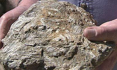
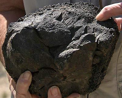
Each rock has its own story, and we've selected a bunch of typical rocks from Idaho, kind of in chronological order.
Dunite: This first rock here came from near New Meadows. It's a rock type called Dunite. It was formed when a piece of the sub-oceanic sea floor got pushed up onto the continent, and then it got heated as the Idaho batholith was emplaced. And the brown stuff in here got turned into this really fancy fibrous mineral which is anthophyllite. Later, as it cooled off, that was turned into talc; so this rock has a really interesting history, and it tells us a lot about how that part of western Idaho formed.
It's an interesting rock because it was originally mainly the mineral olivine, which is a very high temperature mineral; but after it was in its final resting place, the Idaho batholith was injected nearby and heated it up and added a little bit of water. So this nice fibrous mineral and anthophyllite formed at the expense of part of the olivine, and as that cooled off, more water was added; so the mineral talc partially replaces the anthophyllite.
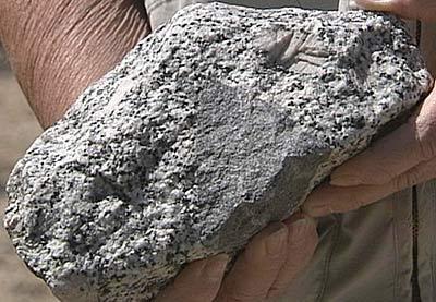
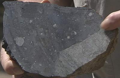
Granite: And going almost to the other end of the state, from way up near Bonners Ferry, we have a nice piece of granite with a dark inclusion. That was probably the country rock into which the molten magma seeped, and it seeped around cracks and incorporated this piece of darker rock.
It's typical granite in that it's got these great big pink things that glint when you rotate them in the sunlight, and they are called potassium feldspar. They are characteristic of high level granites. There are some mafic minerals — the ones that are dark colored and have magnesium and iron in them — but not a whole lot, so this is a pretty typical granite intruded into the older rocks of northern Idaho.
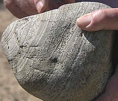
Sedimentary rock: This next rock here is this sedimentary rock, part of the Paleozoic package of rocks in central Idaho. Some of the older part of the Idaho batholith came up under it, metamorphosed it, so it turned the original carbonate minerals into things like augite and scapolite and anorthite, and you see the very delicate banding in it preserved all the way through metamorphism.
If you look carefully, you see this really pointy thing. The thing may have been folded very tightly in sometime in its history before it got thoroughly metamorphosed. And then erosion dropped a chunk of this off in the stream systems, and it got rounded into the big river cobble that you see today.
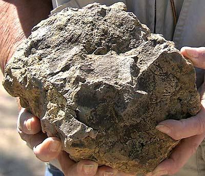
Volcanic rock: This is certainly one of my favorite pet rocks. It comes from a Challis-age caldera in northern Idaho near where I live. I live in Moscow, and this comes from Deary, a small town east of Moscow. There's a unique feature called Potato Hill. Everyone asks if it is a volcano because it is kind of shaped that way, and the answer is . . . Yes and No.
It's not a present day volcano. It's about 50 million years old. It's a volcanic rock that has brought up with it great chunks of both Idaho batholith rocks and rocks of the sedimentary Belt Super group. The caldera is not perfectly preserved but one can see that this is one of the products probably fairly early in the eruption when water got into cracks and caused it to erupt explosively, so it had the carrying power to bring all these big pieces of pre-existing rock.
It's kind of a lone volcano up there, not clustered the way they are in central Idaho, but this is a 50 million year old Challis rock.
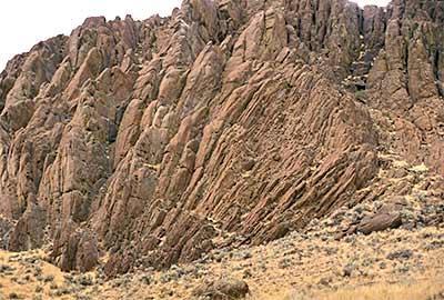
Rhyolite: Okay, this next guy here is one of my favorites. It's a piece of rhyolite; and rhyolite comes in many colors, sometimes black when it's still glassy and sometimes red. This has a nice purple tint, and then you see that it is layered.
This rock formed as huge eruptions of rhyolite laced with water exploded out of the earth, spread as a wide ash flow sheet; but it was so hot, it coalesced back to flowing material that behaved like lava. In the process of doing that, it became crystalline; but before that, flow layers in the flowing material were formed into tight folds. You can see these very tight isoclinal folds here. It's a typical rhyolite of the Snake River plain. It's a pretty piece of rhyolite.
Columbia River basalt: No pet rock display in Idaho could be complete without some piece of the Columbia River basalt, one of the famous formations in Idaho. And this is a piece of a basalt pillow where a flow of the Columbia River basalt was flowing up the valley of a fairly consequential stream with a lot of water in it. So it made pillows; it exploded and made this yellow stuff, which geologists call palagonite. It's kind of a clay that comes from the minerals of the basalt that are altered in hot water.
This was exposed in a road cut where on either side there are rocks of the Idaho batholith, so this was a tongue of a basalt flow that flowed up a valley — a steep-sided valley that was already cut in rocks of the Idaho batholith.
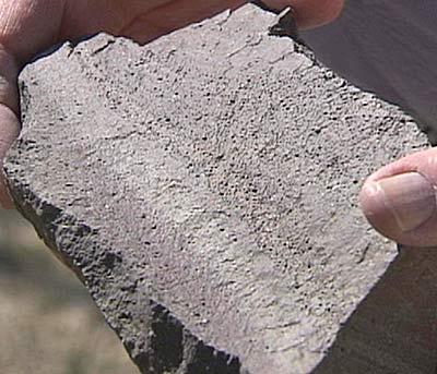
Sandstone: This rock is a sandstone. It looks gray and ugly until you get a little bit closer, and you find shells incorporated in it.
So, what happened was there was this big lake in southwestern Idaho — Lake Idaho — and sand and volcanic ash washed into the sides of it and made muddy banks. A lot of shell fish grew in that environment, including these turritellid gastropods that you can see here.
These shells grew in that, and then that sediment was buried, and later in time, solutions migrating through the area made a concretion; so the body of rock itself was a concretion cemented by calcite, and it has incorporated the shells in it, so it is preserved in that fashion.
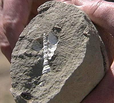
Basalt: And the final pet rock for our display is one of the youngest rocks we ever hope to find in Idaho, and this comes from near Craters of the Moon. It is what we would call a cored bomb. The internal part is a slightly older basalt — older perhaps only by a thousand or two thousand years — and then there's this vesicular scoria coat around that; so a rock from one eruption gets caught up in the frothy gas-rich phase of an eruption that comes afterwards, and is blown out of the volcano to go through the air making a whistling sound that you've probably seen on nature programs about Kilauea.


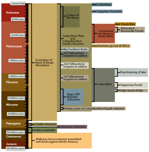
Timelines
Photos from "Idaho Geology, in About a Minute"
Once upon a time, but only about 200 million years ago, Future Idaho was lying there, dumb and happy, in the form of very old metamorphic rocks folded up under layers of Precambrian and Paleozoic marine sediments, while the last of the mid-continental seaway was vanishing from North America and as the continent was breaking up with the rest of the Pangaean supercontinent.
Then, right out of the Pacific, the Wallowa microcontinent crashed into, and scraped along, the west side of Future Idaho. Wham, bam, thank-you ma'am!! Well the consternation that followed included squeezing bits of oceanic seafloor between the two masses and starting the subduction of the Pacific seafloor under the continent.
As you might imagine, things really began to get hot, as huge volumes of granitic magma were melted out of the sinking seafloor, and rose up into the continent's edge to form the gigantic Idaho, Kaniksu, and other batholiths between about 100 and 65 million years ago.
The bulging up during this time caused most of the Precambrian and Paleozoic sedimentary layers to slide eastward from over the batholith, becoming complexly folded and faulted and forming eastern Idaho's overthrust belt.
But wait, the hot times were only beginning. Continued melting down below between about 55 and 40 million years ago let more magma rise up and erupt explosively to form the Challis volcanic field, with its gigantic calderas and accompanying Eocene granite plutons that pierce the Idaho batholith.
After only a few million years of rest, the lower regions provided another humungous, and even hotter, supply of magma. Starting about 17 million years ago basalt lavas erupted through swarms of dikes, to coalesce into the Columbia River basalt fields of western Idaho and eastern Washington and Oregon.
By this time Future Idaho was starting to look like a battleground, with old volcanoes scattered around, fault-block mountain ranges forming and eroding, rivers that were cutting deep canyons, and giant, but temporary, lakes dotting the landscape.
But still no rest for Future Idaho — somehow the Yellowstone hotspot formed down deep near where Idaho, Oregon, and Nevada meet about 14 million years ago. Hot basaltic magma coming up from the hotspot melted big zones of the crust where the batholiths had previously been, making large pools of rhyolitic magma that erupted as a series of supervolcanoes — gigantic calderas — which line up SW to NE across southern Idaho to the site of current activity at Yellowstone.
Then basalt lavas erupted in the supervolcano track to form the Eastern Snake River Plain about as it is now. But wait, while this was going on, the Western Snake River Plain region was stretched in a SW-NE direction to form a big deep basin. This was filled with Lake Idaho, a Lake Ontario-sized body of water about 1500 feet deep, that lasted from about 12 to 2 million years ago, and only drained away once Hells Canyon was cut to its present depth.
Then, out of the north, came the final big act — the Pleistocene Ice Ages. Glaciers formed on many mountain ranges and eroded high peaks into their present forms. And in northernmost Idaho, a tongue of the continental glacier flowed down the Purcell Trench to form a large ice dam, impounding the huge glacial Lake Missoula in western Montana.
Each time this lake rose too high it breached its ice dam to let torrents of water race across northern Idaho, filling in the Rathdrum Prairie with gravel, and coursing across the basalt fields eroding Washington's channeled scablands.
Not to be outdone, about 17,500 years ago, Utah's Lake Bonneville also got so full that it overflowed into southeastern Idaho. This flood followed the courses of the Portneuf and Snake Rivers on its way to the ocean, leaving behind interesting deposits like the Melon Gravel boulder fields.
But the geological good times haven't yet ended, as volcanic activity certainly will happen again — the youngest flows at Craters of the Moon are only about 2000 years old — and mountains are still rising, as indicated by the most recent major earthquake near Borah Peak in 1983.
So, who knows what the next 200 million years might bring, but I bet it will be exciting! The Earth is a dynamic planet and Idaho clearly proves it!
Although geologic events that have been part of Idaho's development have gone on for at least 3 billion years, as evidenced by the oldest rocks in the state, most of the action leading to Idaho's magnificent landscape occurred only in the last 200 million years, or so. Some of the main things that happened are included in the accompanying time line. The events shown are by no means all that has happened in Idaho's history; these are only some of the really main events, and can help the reader by being a framework against which other events can be compared.
There are tectonic events in which parts of continents move around and during which mountains are formed, such as the impingement of the Wallowa microcontinent against the western side of North America, and the crustal stretching that occurred throughout western North America that led to the formation of numerous basin-and-range mountain ranges.
The melting of large volumes of rock deep within the earth, time after time, led to the formation of enormous quantities of magma that rose up towards the surface. Those magmas that didn't quite get that far crystallized in the earth's crust, forming large plutons, of which the Idaho batholith is Idaho's prime example, while those magmas that got to the surface exploded or flowed out to cover large areas, such as the Snake River Plain, with lava flows and ignimbrites (volcanic rock layers resulting from explosive eruptions).
Erosion and deposition processes that occur on the earth's surface because of water or ice have always had a major effect on landscape development. In Idaho, these include the deposition of many marine sediments layers before 200 million years ago (so these aren't in the time line), the development of Lake Idaho in the western Snake River Plain, a tectonically-induced depression, and later erosion from ice flowage and the Bonneville and Missoula megafloods that cut some of Idaho's major valleys and canyons.
Finally, just to give some perspective, some of the life events are shown in the time line, including the last really major extinction event, the loss of the dinosaurs, and the eventual rise of man. In the time line, one should note that the scale changes from place to place. This is because more and more space was needed to show all of the events in the more recent history of Idaho's development.
Learn More About Idaho's Geology
These are some of the best places we discovered for learning more about Idaho's remarkable geology.
- Idaho Geological Survey: The Survey is a statewide public service and research agency housed at the University of Idaho. Lots of good stuff here.
- Digital Atlas of Idaho: Idaho's natural history online, from the Idaho Museum of Natural History.
- Digital Geology of Idaho: The equivalent of an introductory course on the geology of Idaho. Idaho State University.
- Ice Age Floods: Learn about the Missoula and Bonneville floods, which had a significant effect on the geology and terrain of north Idaho and eastern Washington.
- Article: "The Floods That Carved the West": On the Lake Missoula Floods, from Smithsonian Magazine (PDF).
- U. S. Geological Survey: The federal source for science about the earth, its natural and living resources, natural hazards and the environment.
- Idaho's Treasure: The Eastern Snake River Plain Aquifer: From the Idaho National Laboratory and the Idaho Department of Environmental Quality (PDF).
Producer's Notes
Welcome to "Idaho Geology, a Convergence of Wonders," an hour-long show devoted entirely to a comprehensive exploration of Idaho's crazy geology.
For my money, it's the most complex show we've ever attempted. I say that not just because I find the topic to be intimidating. But, as I look at the dozens and dozens of tapes that director/editor Pat Metzler is digitizing into our Avid editing machine at low resolution (so as not to choke the computer), I'm convinced that no one else in his right mind would even attempt such a project.
Our tapes go as far back as the explosion of Mt. St. Helen's in 1980 and the Borah earthquake of 1983. And they include the aerial helicopter footage that colleagues Jeff Tucker and John Crancer brought back a few months ago; not to mention the footage we shot just this past week, of Blue Heart Springs near Hagerman and of Black Magic Canyon near Shoshone. These last two excursions alone prove that Idaho holds surprises for even those who think they know their state!
Since the days of Lewis and Clark, Idaho's geology has inspired and frustrated every generation. Luckily, we have geologists Bill Bonnichsen and Marty Godchaux, to walk us through the complexities of the topic. Bill is world-renowned when it comes to understanding the Snake River plain. And his wife Marty is a volcanologist of the first order.
We interviewed them for three days straight in various locations, like Craters of the Moon and the Sawtooth National Recreation Area, and asked them every conceivable question we could think of relating to Idaho's geology.
It may surprise you to learn that two of the world's greatest floods occurred here in Idaho; that there is a huge difference between the mountains of central Idaho's batholith and those of the Basin and Range province; and that the ancient volcanoes of the Snake River plain share a lineage with what is happening today at Kilauea in Hawaii.
"I can't think of another state that has anything better than we have here," stated geologist Marty Godchaux; and I wholeheartedly agree.
But we didn't just leave it to the geologists to tell the story. We also met up with hardy recreationists on the back side of Bruneau Dunes for some sand skiing. We dropped into Class V water with adventurous kayakers at Succor Creek; and we filmed rafts flipping at high water at Lochsa Falls. We met up with two of Idaho's world-class climbers at City of Rocks. And we took scuba gear into delightful Blue Heart Springs near Hagerman.
More than anything, we wanted to make "Idaho Geology" accessible to every Idahoan, from the highly educated to those just learning about how their world works.
The website for this production is one of our best ever. We have a section called "My Private Idaho," featuring our Outdoor Idaho Facebook photographer friends; and we have sections featuring some original work by geologists Bill Bonnichsen and Marty Godchaux, including a section on their favorite Idaho rocks.
Through this entire project, we have attempted to explore the forces that unite us, and divide us, and bind us together as a state. That's a tall order. And even though this show has been incredibly time-consuming, we realize we've only scratched the surface of this remarkable state.
Episode Gallery